
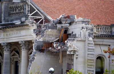
7.1 Earthquake in Christchurch, New Zealand.

7.1 Earthquake in Christchurch, New Zealand.

7.1 Earthquake in Christchurch, New Zealand.

7.1 Earthquake in Christchurch, New Zealand.

7.1 Earthquake in Christchurch, New Zealand.

7.1 Earthquake in Christchurch, New Zealand.

7.1 Earthquake in Christchurch, New Zealand.

7.1 Earthquake in Christchurch, New Zealand.

7.1 Earthquake in Christchurch, New Zealand.

A photograph looking south down Colombo Street from the intersection of Hereford Street. Pieces of pipe are lying in the gutter and pavement bricks have been upturned.

Photograph captioned by BeckerFraserPhotos, "Remains of the Convention Centre and the Crowne Plaza Hotel, south-east corner Durham and Kilmore Streets. Town Hall (top centre)".

Photograph captioned by BeckerFraserPhotos, "Looking south along Kerrs Road which is zoned red in the foreground where it has slumped. Further along it's zoned green".

Photograph captioned by Fairfax, "Christchurch is open again but it just doesn't seem the same to these two walking across Manchester Street just south of Worcester".
Earthquake damage to the south-west corner of the Cathedral of the Blessed Sacrament. Broken furniture can be seen in a room exposed by the fallen walls.

Manchester Street looking south-ish, near the corner of Worcester Street. The is the Trinity Building, which housed a restaurant and live music venue called Octagon Live.

A photograph showing Colombo Street, looking south towards Cathedral Square from the intersection with Cambridge Terrace. The partly demolished Mutual Funds Life building is visible above the trees.

A photograph of street art on a water tank at Central New Brighton School. The school was closed in 2014 after being merged with South New Brighton school.

A photograph captioned by BeckerFraserPhotos, "A view looking south along Wattle Drive, New Brighton towards the Port Hills. This part of the street is red zoned".

A photograph captioned by BeckerFraserPhotos, "Looking along the south side of Cashel Street and Cashel Mall. Part of the Southern Star building is on the left".

A photograph of street art on a water tank at Central New Brighton School. The school was closed in 2014 after being merged with South New Brighton school.

The community centre in my old neighbourhood. Now it's an empty lot.

The community centre in my old neighbourhood. Now it's an empty lot.

None

None

A photograph of tape artists from Skillwise standing in front of the south wall of Community and Public Health while Struan Ashby from Tape Art NZ starts creating the mural. The photograph was taken at Street Talk, a Tape Art residency held from 6 - 9 March 2014. Street Talk was a collaborative project between All Right?, Healthy Christchurch and Tape Art NZ that had Christchurch communities create large tape art murals on the south wall of Community and Public Health.

One landscape colour digital photograph taken on 16 June 2011 showing the Lyttelton Bakery operating from a portable building on the Corner of Canterbury Street and Norwich Quay. This portable building has been placed on the site of the Royal Hotel. Also visible in the photograph are Shadbolt House and the rear of the buildings on the south side...

A photograph looking south down Colombo Street from the intersection of Armagh Street. The road has been cordoned off and an excavator is demolishing a building on the right.

A photograph looking south towards the PricewaterhouseCoopers Building from Colombo Street. In the background, two cranes can be seen. The Ernst and Young Building is to the left.

A photograph captioned by BeckerFraserPhotos, "Looking south along Manchester Street from Kilmore Street to the giant crane being readied for the demolition of the Hotel Grand Chancellor".

Photograph captioned by BeckerFraserPhotos, "St Luke's Church on Kilmore Street. The south apse wall was further damaged during the 13 June 2011 earthquake, exposing the pipe organ".