
Liquefaction dug out of properties and piled on the streets in Avonside after the September 4th earthquake.

Cones marking a crack in the centre of a street in Avonside after the September 4th earthquake.

Cracks in the parking lot in front of a store in Kaiapoi, after the September 4th earthquake.

Liquefaction and damage to tiles in front of a store in Kaiapo, after the September 4th earthquake.

Spice Traders is open again following the February earthquake.

Exterior of the Engineering library following the September earthquake.

Prior to the earthquake, this was a lovely backyard lawn covered with green grass -- !!
Penrith Avenue, Somerfield, Christchurch.

Photo of the earthquake damage of a residential property brick fence in Christchurch taken by Marcus Langman, 10 March 2011.

A graph showing the probability of earthquakes in Canterbury.

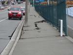
Photograph captioned by Fairfax, "Road damage following Canterbury's earthquake".

Photograph captioned by Fairfax, "Road cracked following Canterbury's earthquake".

Photograph captioned by Fairfax, "Damaged roads following Canterbury's earthquake".

Photograph captioned by Fairfax, "Lyttelton harbour following Canterbury's earthquakes".

Photograph captioned by Fairfax, "Damaged road following Canterbury's earthquake".

Photograph captioned by Fairfax, "Digging liquefaction following Canterbury's earthquake".

Christchurch Cathedral, Cathedral Square

Christchurch Cathedral, Cathedral Square

A photograph of members of SPCA Canterbury conducting a meeting in the Rescue Coordination Centre after the 22 February 2011 earthquake.

Christchurch Cathedral, photo taken from the Warners Novotel, Cathedral Square.

One book titled "Earthquake, Christchurch New Zealand 22 February 2011" with text by Chris Moore and Press journalists and images by Press and Fairfax photographers; colour illustrations; published by A Random House New Zealand, Auckland, 2011; accompanying DVD. The sombre tone of this book and DVD reflects the attitudes of the greater Christch...

One right rear black Mazda CX7 car door damaged during the 22 February 2011 earthquake; white USAR spray paint markings 'P/T // CLE[AR]'. This panel once belonged to a Mazda CX7 car that was crushed by falling rubble during the 22 February 2011 earthquake. Considerably bent out of shape, it demonstrates the potential danger from falling masonry...
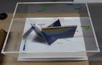
One oblong perspex covered 3-D model of the fault plains associated with the 4 September 2010 Darfield earthquake; top of the model also acts as a map overlay. Geologists continue to study the 4 September 2010 earthquake and consider it is likely to have been a complex event with several faults rupturing simultaneously. This model provides one ...

One landscape colour digital photograph taken on 25 February 2011 showing earthquake damage to the Presbyterian Church of St John in Winchester Street Lyttelton. Photograph shows the main doors, roof and collapsed tower at southern end of church. Architect St John's Lyttelton was one of the oldest Presbyterian Churches in Canterbury. The New Ze...
One landscape colour digital photograph taken on 25 February 2011 showing earthquake damage to the road, footpath and retaining wall on Norwich Quay. The photograph is taken from below the intersection of Norwich Quay and Canterbury Street looking east along Norwich Quay. Unlike most areas of Christchurch, land damage on the Port Hills was due ...

One landscape colour digital photograph taken on 6 September 2010 showing earthquake damage to a van caused by red bricks from the Christchurch Chinese Methodist Church, 165 Papanui Road. The Christchurch Chinese Methodist Church on Papanui Road sustained severe damage during the 4 September 2010 earthquake. Constructed from unreinforced red br...

One landscape colour digital photograph taken on 6 September 2010 showing earthquake damage to buildings on Victoria Street near Bealey Avenue. The red brick building is the Knox Church; it still stands on the corner of Bealey Avenue and Victoria Street following the earthquake, though some extreme measures were taken to make it safe. The red b...

One landscape colour digital photograph taken on 6 September 2010 showing earthquake damage to the red brick building of the Christchurch Chinese Methodist Church, 165 Papanui Road. The Christchurch Chinese Methodist Church on Papanui Road sustained severe damage during the 4 September 2010 earthquake. The red placards placed on the door of the...

One landscape colour digital photograph taken on 6 September 2010 showing earthquake damage and a red placard on the red brick building of the Christchurch Chinese Methodist Church, 165 Papanui Road. The Christchurch Chinese Methodist Church on Papanui Road sustained severe damage during the 4 September 2010 earthquake. The red placards placed ...

One landscape colour digital photograph taken on 27 April 2011 showing damage to the London Street Restaurant. Photograph taken looking west from the intersection of London Street with Oxford Street and Sumner Road. Adaptability and quick thinking has become a key part of business survival in post earthquake Canterbury. The owner of this bui...

One landscape colour digital photograph taken on 15 June 2011 showing earthquake damage to the Presbyterian Church of St John in Winchester Street, Lyttelton. Photograph shows the collapsed roof and tower. The photograph is taken from the southeast corner of the church. Architect St John's Lyttelton was one of the oldest Presbyterian Churches in...