
Large cracks on a street in Avonside barred off with police tape after the September 4th earthquake.

Liquefaction dug out of properties and piled on the streets in Avonside after the September 4th earthquake.

Cones marking a crack in the centre of a street in Avonside after the September 4th earthquake.

Cracks in the parking lot in front of a store in Kaiapoi, after the September 4th earthquake.

Liquefaction and damage to tiles in front of a store in Kaiapo, after the September 4th earthquake.

Christchurch Cathedral, Cathedral Square

Christchurch Cathedral, Cathedral Square

Photo of the earthquake damage of a residential property brick fence in Christchurch taken by Marcus Langman, 10 March 2011.

Christchurch Cathedral, photo taken from the Warners Novotel, Cathedral Square.

Spice Traders is open again following the February earthquake.

Exterior of the Engineering library following the September earthquake.

A photograph of members of SPCA Canterbury conducting a meeting in the Rescue Coordination Centre after the 22 February 2011 earthquake.

A graph showing the probability of earthquakes in Canterbury.

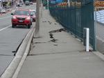
Photograph captioned by Fairfax, "Road damage following Canterbury's earthquake".

Photograph captioned by Fairfax, "Road cracked following Canterbury's earthquake".

Photograph captioned by Fairfax, "Damaged roads following Canterbury's earthquake".

Photograph captioned by Fairfax, "Lyttelton harbour following Canterbury's earthquakes".

Photograph captioned by Fairfax, "Damaged road following Canterbury's earthquake".

Photograph captioned by Fairfax, "Digging liquefaction following Canterbury's earthquake".

One six-wheeled Rover 3 remote controlled vehicle in hard-shell storage box and one handset control unit (transmitter), colour monitor with cabling (and A/V receiver) and three batteries in a second smaller hard-shell storage box.

One landscape colour digital photograph taken on 15 June 2011 showing earthquake damage to the former Canterbury Hotel and adjoining row of shops on Oxford Street. This photograph was taken on Oxford Street and shows the collapsed façade of the row of shops behind safety fencing, the interior of the building is exposed. Shadbolt House is visib...

One landscape colour digital photograph taken on 15 June 2011 showing earthquake damage to the former Canterbury Hotel and adjoining row of shops on Oxford Street. This photograph was taken on Oxford Street and shows the collapsed façade of the row of shops behind safety fencing, the interior of the building is exposed. The design of many older...

Two men chat over the fence about the state of their houses after the 4th September earthquake in Christchurch. One of them is complaining about the slow pace of reconstruction of houses after the magnitude 7.1 earthquake on 4 September 2010; the second man thinks they are doing their best. Context - Frustration over the slow rate of processing insurance applications and building inspections after the magnitude 7.1 earthquake on 4 September 2010 which although it resulted in a lot of damage, no-one died. In the cartoon the man's red sticker (meaning the house is uninhabitable) has faded to green after being put on the house after the September earthquake. Three days after this cartoon was published the much more disastrous earthquake of the 22nd February struck and many people died.
Quantity: 1 digital cartoon(s).

Damage from the Christchurch 7.1 earthquake on 4th Sept 2010

One book titled "Earthquake, Christchurch New Zealand 22 February 2011" with text by Chris Moore and Press journalists and images by Press and Fairfax photographers; colour illustrations; published by A Random House New Zealand, Auckland, 2011; accompanying DVD. The sombre tone of this book and DVD reflects the attitudes of the greater Christch...

One right rear black Mazda CX7 car door damaged during the 22 February 2011 earthquake; white USAR spray paint markings 'P/T // CLE[AR]'. This panel once belonged to a Mazda CX7 car that was crushed by falling rubble during the 22 February 2011 earthquake. Considerably bent out of shape, it demonstrates the potential danger from falling masonry...
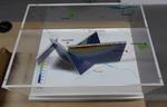
One oblong perspex covered 3-D model of the fault plains associated with the 4 September 2010 Darfield earthquake; top of the model also acts as a map overlay. Geologists continue to study the 4 September 2010 earthquake and consider it is likely to have been a complex event with several faults rupturing simultaneously. This model provides one ...

One landscape colour digital photograph taken on 25 February 2011 showing earthquake damage to the Presbyterian Church of St John in Winchester Street Lyttelton. Photograph shows the main doors, roof and collapsed tower at southern end of church. Architect St John's Lyttelton was one of the oldest Presbyterian Churches in Canterbury. The New Ze...
One landscape colour digital photograph taken on 25 February 2011 showing earthquake damage to the road, footpath and retaining wall on Norwich Quay. The photograph is taken from below the intersection of Norwich Quay and Canterbury Street looking east along Norwich Quay. Unlike most areas of Christchurch, land damage on the Port Hills was due ...

One landscape colour digital photograph taken on 6 September 2010 showing earthquake damage to a van caused by red bricks from the Christchurch Chinese Methodist Church, 165 Papanui Road. The Christchurch Chinese Methodist Church on Papanui Road sustained severe damage during the 4 September 2010 earthquake. Constructed from unreinforced red br...