
Damage to the Cathedral of the Blessed Sacrament. The south-west corner of the building has collapsed, exposing the rooms inside, and the north-west corner is supported by shipping containers.

Dried liquefaction silt in North New Brighton. The photographer comments, "Here you can see the very fine surface layer of liquefaction starting to shrink, crack and then curl up on itself".

Photograph captioned by BeckerFraserPhotos, "The north-west corner of Manchester and Gloucester Streets (Map World). Extensive frontal collapse of the Gloucester Street frontage during the 13 June 2011 earthquake".

Damage to the Cathedral of the Blessed Sacrament. The south-west corner of the building has collapsed, exposing the rooms inside, and the north-west corner is supported by shipping containers.

A photograph looking north along the footpath of Bangor Street. To the right there are the former sites of several houses. The houses were demolished after the land was zoned Red.

Damage to the Cathedral of the Blessed Sacrament. Extensive damage can be seen on the north-west and south-west corners of the building, and cracking is visible underneath the dome.

Damage to the Cathedral of the Blessed Sacrament. The south-west corner of the building has collapsed, exposing the rooms inside, and the north-west corner is supported by shipping containers.

An aerial photograph of a residential area in Burwood.

Residents working to clear liquefaction from their properties in north-east Christchurch. The liquefaction has been piled on the side of the road where it will be collected by road maintenance contractors.

Photograph captioned by Fairfax, "Arnold and Joy Pohio of Kaiapoi, north of Christchurch, speak of their son Joseph Pohio 40 yrs, who was killed during the earthquake while in the central city."

Photograph captioned by BeckerFraserPhotos, "Corner of Manchester and Gloucester Streets with the site of Iconic in the foreground and the SBS building being demolished to the right. North-east view".

A photograph looking north down Colombo Street towards the intersection of Armagh Street. The road has been fenced off and a large pile of building rubble can be seen in the distance.

A photograph of Lee from Healthy Christchurch taking part in #FiveYearsOn. Lee holds a sign which reads, "Five years on, I feel... Ready and Calmer// Lee Tuki North New Brighton".

An aerial photograph captioned by BeckerFraserPhotos, "A aerial view looking north-west over Christchurch with the River Avon in the foreground and Horseshoe Lake in the centre of the photo".

A resident using a small digger to clear liquefaction from his property in north-east Christchurch. He is piling the liquefaction on the side of the road where it will be collected.

These have been thrown in the Avon River

None

One of many disabled carparks outside what used to be one of the great sporting complexes in New Zealand. The Queen Elizabeth II Park complex in north-east Christchurch was built initially for the 1974 Commonwealth Games and was used for track and field and the adjoining pool complex had swimming and diving. It was built on an area that was used...

Awaiting demolition

Awaiting demolition. Blue pipes are water supply to anyone still living on Hulverstone Drive.

Prior to the earthquakes (mainly the February 22 2011 event) this park bench was at track level. Shortly after the February quake someone in the council did the sums and realised that the area near the Avon River had dropped between a metre and 1.4m (about 4 foot), so a rush job by contractors shifted in many tonnes of rock and gravel to raise a...
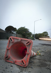
A month after the 1st anniversary of the deadly Christchurch earthquake (22/02/11) a road cone lies on New Brighton Road, alongside the Avon River.
Part of the earthquake 1st anniversary remembrance was for people to place flowers in road cones (and there are hundreds of thousands in the city). Many had flowers in them, as this one did.
Photo ...

None

A local resident walks to the nearest dairy for essentials after the 7.1 magnitude quake, that has caused major infrastructure damage to Christchurch City.

Cracking around the lamp post at the north end of Cranmer Square. In the background, crowds of people are standing around the square, where they evacuated to after the 22 February 2011 earthquake.

Photograph captioned by Fairfax, "Helping out: Daiken, ITM and Linfox step up and donate time, goods and information to the people of North Canterbury who have been affected by the 4 September earthquake".

Damage to the north side of the cathedral. A walkway from Gloucester Street to the Square was opened up for a few days to allow the public a closer look at the cathedral.

The Christ Church Cathedral viewed from north Colombo Street. The collapsed tower can be seen as well as emergency personnel, including members of the police and the fire service, working in the rubble.

Damage to the north side of the Cathedral. A walkway from Gloucester Street to the Square was opened up for a few days to allow the public a closer look at the Cathedral.

Damage to the north side of the Cathedral. A walkway from Gloucester Street to the Square was opened up for a few days to allow the public a closer look at the Cathedral.