
A photograph of a detail of the former Post Office building in Lyttelton.

A photograph of a window of the factory building at 5 Olliviers Street.

A photograph of the foundations of the demolished building at 198 Gloucester Street.

A photograph of the site of a demolished building at 421 Cashel Street.

A photograph of the site of a demolished building at 421 Cashel Street.

A photograph of the site of a demolished building at 469 Colombo Street.

A photograph of the site of a demolished building at 820 Colombo Street.

A photograph of the site of a demolished building at 333 Barbadoes Street.

A chimpanzee paints with a palette of colours. Context: After the earthquakes in Christchurch buildings and areas were designated green, blue, red or white depending on the degree of damage. Buildings in the 'red' zone were then examined to ascertain whether they should be demolished or restored and sometimes the land itself was deemed unsafe. There have been many controversial decisions made which is the point the cartoon makes.
Quantity: 1 digital cartoon(s).

A map showing earthquake-prone buildings in Selwyn district.

Photograph captioned by Fairfax, "Damaged building, Oxford Street, Lyttelton".

Photograph captioned by Fairfax, "Damaged building, Norwich Quay, Lyttelton".

A map showing the location of a building site.
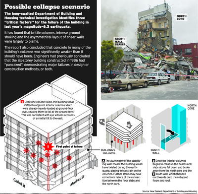
An infographic describing the collapse of the CTV building.

Photograph captioned by Fairfax, "Strategy Design building partially demolished".

Photograph captioned by Fairfax, "Closed backpackers (earthquake damaged) building".

Photograph captioned by Fairfax, "Building damage after Christchurch earthquake".

Photograph captioned by Fairfax, "Building damage after Christchurch earthquake".

Photograph captioned by Fairfax, "Building damage after Christchurch earthquake".

A page banner promoting an article titled, "CTV building".

Photograph captioned by Fairfax, "Closed backpackers (earthquake damaged) building".

Photograph captioned by Fairfax, "Closed backpackers (earthquake damaged) building".

Photograph captioned by Fairfax, "Building damage after Christchurch earthquake".

Members of the New Zealand and Chinese Urban Search and Rescue (USAR) teams clearing rubble on the site of the CTV Building.

An aerial view of Christchurch a week after the 22 February 2011 earthquake. The PGC Building on Cambridge Terrace can be seen.

A truck fire fighter from the Christchurch City Council Rural Fire Authority spraying water on the road next to the CTV Building.

An aerial view of Christchurch a week after the 22 February 2011 earthquake. The PGC Building on Cambridge Terrace can be seen.

Aerial image of the CTV Building site on Madras Street, taken by the Royal New Zealand Air Force for the Earthquake Commission.

A member of the Chinese Urban Search and Rescue teamwatching as a digger clears rubble on the site of the CTV Building.

The damaged Ozone Hotel on Marine Parade. Fallen bricks lie on the ground in front of the building, which is surrounded by security fencing. The photographer comments, "A bike ride to New Brighton and the beach 3 weeks after the Feb 22 quake. Roads were still very rough and under reconstruction. Some buildings are still standing. but don't look too healthy".