
Photograph captioned by BeckerFraserPhotos, "The lights are on at the new Press building, the first office workers to return to the central city red zone".

Photograph captioned by BeckerFraserPhotos, "3 Meadow Street, Kaiapoi. This side of the street is blue-green (Technical Category 3) and the opposite side is red zoned".

A public walkway down Colombo Street to a viewing area in the Cathedral Square was opened up for a few weekends to allow the public to see inside the Red Zone.

A public walkway down Colombo Street to a viewing area in the Cathedral Square was opened up for a few weekends to allow the public to see inside the Red Zone.

A public walkway down Colombo Street to a viewing area in the Cathedral Square was opened up for a few weekends to allow the public to see inside the Red Zone.

Photograph captioned by BeckerFraserPhotos, "Seabreeze Close and Wetlands Grove, Bexley".

A photograph of a shop window with large letters stating, "Yes we are open". The window also bears a red sticker and spray painted notes from 26 February 2011 stating "Rear collapsed".

Photograph captioned by BeckerFraserPhotos, "Micham Place, Fordingham and Sopley Lanes, Bexley".

A snapshot from GPS Boomerang's SmartBird flight over the Christchurch red zone on 5 June 2012, looking over Cathedral Square with the Christchurch Cathedral, the Post Office Building and the Chalice visible.

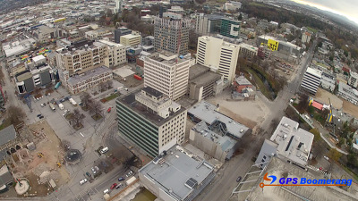
A snapshot from GPS Boomerang's SmartBird flight over the Christchurch red zone on 23 December 2012, looking over Hereford Street with the BNZ Building almost demolished in the centre left.

A rubbish truck collects rubbish from the red bins along Rocking Horse Road in Southshore. The uneven surface of the road can be seen, with water pooling in the foreground.

Photograph captioned by BeckerFraserPhotos, "A view of Real Groovy from the top of Alice in Videoland".

Photograph captioned by BeckerFraserPhotos, "The view from the top of Alice in Videoland".

A snapshot from GPS Boomerang's SmartBird flight over the Christchurch red zone on 5 June 2012, looking over Victoria Square with the Forsyth Barr Building, the Victoria Apartments and the PriceWaterHouseCoopers Building visible.

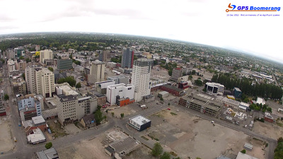
A snapshot from GPS Boomerang's SmartBird flight over the Christchurch red zone on 5 June 2012, looking over the Town Hall and Victoria Square with the site of the Crowne Plaza Hotel visible in the bottom left.

A snapshot from GPS Boomerang's SmartBird flight over the Christchurch red zone on 23 December 2012, looking over Cathedral Square with the Cathedral and the Post Office visible. The BNZ Building has been partially demolished.
A snapshot from GPS Boomerang's SmartBird flight over the Christchurch red zone on 23 December 2012, looking over Bedford Row with Latimer Square in the distance to the left. The Newstalk ZB Building has been demolished.

A photograph captioned by BeckerFraserPhotos, "Christmas cone decorations linger on in Kingsford Street, Horseshoe Lake, Burwood".
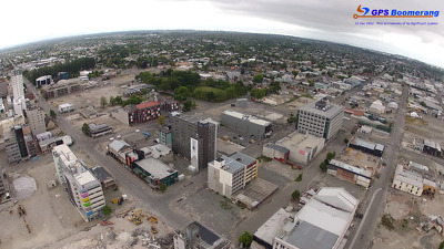
A snapshot from GPS Boomerang's SmartBird flight over the Christchurch red zone on 5 June 2012, looking over Gloucester Street with the Cathedral visible on the bottom left and Oxford Terrace to the right.

A snapshot from GPS Boomerang's SmartBird flight over the Christchurch red zone on 23 December 2012, looking over Durham Street with Gap Filler's Pallet Pavilion to the left, on the site of the Crowne Plaza Hotel.

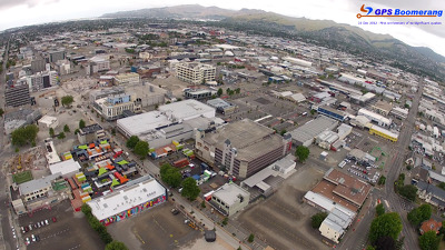
A snapshot from GPS Boomerang's SmartBird flight over the Christchurch red zone on 5 June 2012, looking over Worcester Street with the Rendezvous Hotel visible in the middle and the Octagon Live Restaurant below.

A photograph of a colourful crocheted cover for a shipping container. It has a variety of patterns including a black swan, a red flower, and a heart with "hope" written in it.

Photograph captioned by BeckerFraserPhotos, "High Street with the remains of the Hotel Grand Chancellor and the Holiday Inn and Westpac building (both under demolition). Manchester Street on the left".

Photograph captioned by BeckerFraserPhotos, "The view from the top of Alice in Videoland".

An aerial photograph captioned by BeckerFraserPhotos, "Scarborough cliffs showing the massive rock fall on 13 June. The red roof house (right) above the rock tongue poking into the sea, lost 25m of ground during the fall".

A photograph of a sign reading, "Christchurch Economic Recovery Abandoned - to red tape". The photograph is captioned by BeckerFraserPhotos, "Sign seen on a fence near the corner of St Asaph Street and High Street".

Photograph captioned by BeckerFraserPhotos, "A view of High Street from the top of Alice in Videoland".

A snapshot from GPS Boomerang's SmartBird flight over the Christchurch red zone on 23 December 2012, looking over Victoria Square with the Forsyth Barr Building and the Victoria Apartments visible. The PriceWaterHouseCoopers Building has been demolished.
A snapshot from GPS Boomerang's SmartBird flight over the Christchurch red zone on 23 December 2012, looking over Cashel Street where the Re:Start container mall now sits. The Holiday Inn and Westpac Trust Building have been demolished.
A snapshot from GPS Boomerang's SmartBird flight over the Christchurch red zone on 23 December 2012, looking over Worcester Street with the Rendezvous Hotel visible in the middle and the Octagon Live Restaurant below. The Newstalk ZB Building has been demolished.