
An aerial photograph captioned by BeckerFraserPhotos, "Old Christchurch City Council administration building on Tuam Street".

Photograph captioned by BeckerFraserPhotos, "A view of SOL Square from the top of the Alice in Videoland building on the corner of High Street and Tuam Street".
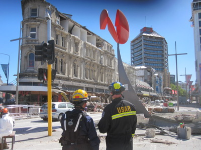
Structural Engineers from the New Zealand and Los Angeles County Fire Department Urban Search and Rescue teams performing assessments of buildings on High Street near Manchester Street.

A photograph of members of the Wellington Emergency Management Office Emergency Response Team working on Tuam Street near the intersection of High Street. In the background are several piles of rubble from earthquake-damaged buildings.

Photograph captioned by BeckerFraserPhotos, "Looking down Poplar Street towards High Street".

A photograph of workers from the Residential Access Project walking down Tuam Street. The project gave residents temporary access within the red-zone cordon in order to retrieve items from their homes.

A photograph of building rubble on Tuam Street, near the corner of High Street.

A photograph of building rubble on Tuam Street, near the corner of High Street.

Photograph captioned by BeckerFraserPhotos, "Hanafins corner, 134 Hereford Street".

Photograph captioned by BeckerFraserPhotos, "Hanafins corner, 134 Hereford Street".

A photograph of a group of people in hi-viz vests at the intersection of High and Manchester Streets.

A photograph of a group of people in hi-viz vests at the intersection of High and Manchester Streets.

An aerial photograph captioned by BeckerFraserPhotos, "Cashel Mall and Colombo Street".

A photograph of members of the Wellington Emergency Management Office Emergency Response Team and the Red Cross working on High and Manchester Streets. On both sides of the street there are piles of rubble from the earthquake-damaged buildings. Several excavators have been parked in a line along the street.

Photograph captioned by BeckerFraserPhotos, "A view looking along High Street towards Cathedral Square. Strange's building can be seen on the left".

Photograph captioned by BeckerFraserPhotos, "Unlimited Paenga Tawhiti secondary school, High Street".

A photograph of the Cotter & Co. building behind wire fencing on High Street. The building formerly housed The National Gallery and New Zealand Tattoo.

A digital copy of a pen and ink and watercolour painting by Raymond Morris, titled, 'C.F. Cotter Ltd, 158 High Street'.

A photograph of the Cotter & Co. building behind wire fencing on High Street. The building formerly housed The National Gallery and New Zealand Tattoo.

A photograph of large cracks in a footpath near the Kaiapoi River.

A photograph of carved stonework lying on the ground at the corner of High Street, Hereford Street and Colombo Street.

A photograph of Majestic House, taken near the intersection of Manchester Street, Lichfield Street and High Street. Lichfield Street has been blocked off by fences and barricades.

A photograph of Majestic House, taken near the intersection of Manchester Street, Lichfield Street and High Street. Lichfield Street has been blocked off by fences and barricades.

A graphic giving the status of Aranui High School.

A snapshot from GPS Boomerang's SmartBird flight over the Christchurch red zone on 23 December 2012, looking over Hereford Street with the BNZ Building almost demolished in the centre left.

A photograph of One Big Sugar Bowl on High Street. USAR codes can be seen spray-painted on the window and a window pane to the left has been boarded up with plywood. Furniture remains on the street.

A photograph of the earthquake damage to the Fisher's Building on the corner of High and Hereford Streets. Large sections of the top storey have collapsed, the masonry spilling onto the footpath and damaging the awning.

An aerial photograph captioned by BeckerFraserPhotos, "Central city blocks bounded by Colombo Street, Hereford Street, Cashel Street, and High Street".

A photograph of an empty site and badly-damaged buildings taken from behind a fence on Madras Street. In the distance is the old Post Office building.

A photograph of emergency management personnel crossing the intersection of High, Colombo, and Hereford Streets. In the background is the earthquake-damaged Fisher's Building. Large sections of the top storey have collapsed, the masonry spilling onto the footpath and damaging the awning.