
One landscape colour digital photograph taken on 19 November 2011 showing part of the north side of London Street. The properties visible from left to right are Lyttel Piko Organic and Wholefoods, and Satchmo Café Pizzabar The Lyttelton streetscape has changed dramatically from its pre-earthquake appearance and will continue to change as new bu...

One portrait colour digital photograph taken on 19 November 2011 showing a poster advertising the planned 2011 Census which was scheduled for Tuesday 8 March 2011. The census was abandoned because of the 22 February 2011 Earthquake. The poster was located in the window of the Lyttelton Information Centre on Oxford Street. The building was closed...

One portrait colour digital photograph taken on 19 November 2011 showing the framework of the Lyttelton Coffee Company Building surrounded by safety fencing. On the fencing are election hoardings and an advertisement for Samo, the café established by employees of the Lyttelton Coffee Company. Prior earthquake strengthening enabled the Lyttelton...

One landscape colour digital photograph taken on 27 May 2013 of London Street in Lyttelton. Taken from Sumner Road looking west across the intersection of London and Oxford Streets. The photograph shows several empty sections and the remaining buildings. The Lyttelton streetscape has changed dramatically from its pre-earthquake appearance and w...

One white over-painted hand-made electric guitar made primarily from ash and maple timbers, also incorporating wood from a variety of historic buildings in Canterbury damaged or destroyed in the 2010 - 2011 earthquakes including the Arts Centre, Kutwell’s Warehouse, Lyttleton main street pub, Timeball Station, Carlton Hotel, Merivale shops, bui...

A page banner with images from the earthquake.

A page banner with images from the earthquake.

One landscape colour digital photograph taken on 19 November 2011 looking east from Norwich Quay from approximately the base of Canterbury Street. Visible in the photograph are the partially deconstructed former Lyttelton Harbour Board Offices, the Holcim Cement Silos, the Oxford Street Railway Overbridge, Lyttelton Port of Christchurch's storag...
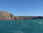
One landscape colour digital photograph taken on 26 May 2013 off Godley Head looking north to Boulder Bay and Taylors Mistake. Rock which fell from the cliffs is heaped at the waters edge. Volcanic banding is visible in the face of the cliffs. There were several major rock falls along the coastal cliffs near Christchurch and Lyttelton Harbour....

One landscape colour digital photograph taken on 26 May 2013 off Godley Head looking north towards Sumner Head. There were several major rock falls along the coastal cliffs near Christchurch and Lyttelton Harbour. In and around the suburb of Sumner some of these falls necessitated the abandonment of houses in areas where cliffs had given way or...

An advertisement for 'The Big Quake', a book about the 4 September earthquake produced by The Press. The advertisement advises that the book has sold out and is being reprinted.

One white dust mask with elastic strap to secure around the head. Black printing on the front reads: '3M 8000 / P1 / AS/NZS 1716'. Used by Student Volunteer Army in the clean up after 4 September 2010 earthquake. Face masks were recommended by Christchurch Public Health staff as a safety precaution for those handling liquefaction. Liquefaction ...

One green koru shaped trophy issued to SCIRT in 2013 to mark winning The Press Champion Canterbury Supreme Award in the Medium-Large Enterprise category. Includes storage box, envelope and leaflet.

Steel frames are being used to shore the unstable facade of the St John the Baptist Church at Latimer Square while the building is being repaired and strengthened following the magnitude 7.1 earthquake that struck Christchurch on Saturday 4 September 2010.

Looking across the faultline where the Saturday 4 September 2010 magnitude 7.1 earthquake originated. Note how much the previously straight fence is now out of alignment.

Looking across the faultline where the Saturday 4 September 2010 magnitude 7.1 earthquake originated. Note how much the previously straight fence is now out of alignment.
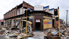
Aftermath of September 4th Earthquake in Canterbury. Shops on Colombo Street in Christchurch - damaged in earthquake and then partially demolished to reduce risk from unstable materials which might otherwise be dislodged in strong winds or subsequent aftershocks. The 1590 aftershocks recorded to date have continued to cause further damage.

Collapsed silos at David Bell Daffodil Farm in Leeston; aftermath of the magnitude 7.1 earthquake that struck mid-Canterbury on Saturday 4 September 2010.

Photograph captioned by Fairfax, "A photograph of the damaged smoke stack of The Mill Theatre after the 4 September earthquake".

Photograph captioned by Fairfax, "Fred Arnesen has reopened after being forced to leave his Beckenham shop following the 4 September earthquake".

Christchurch city experienced a magnitude 7.1 earthquake on September 4 at 4:35 am. The epicentre was 40 km west of the city. It was the most damaging earthquake in New Zealand since the Hawke's Bay earthquake in 1931, but there was no loss of life. It was fortunate the earthquake occurred when the central city streets were deserted, as there w...

Two men chat over the fence about the state of their houses after the 4th September earthquake in Christchurch. One of them is complaining about the slow pace of reconstruction of houses after the magnitude 7.1 earthquake on 4 September 2010; the second man thinks they are doing their best. Context - Frustration over the slow rate of processing insurance applications and building inspections after the magnitude 7.1 earthquake on 4 September 2010 which although it resulted in a lot of damage, no-one died. In the cartoon the man's red sticker (meaning the house is uninhabitable) has faded to green after being put on the house after the September earthquake. Three days after this cartoon was published the much more disastrous earthquake of the 22nd February struck and many people died.
Quantity: 1 digital cartoon(s).

A map showing the earthquake epicentre and new faultline trace.

A logo for the earthquake section of The Press website.

Cracks have ripped through external columns of this 7 storey building (corner of Hereford Street / Manchester Street), and efforts are being made to shore up and strengthen it to save it from demolition after it suffered structural damage in the magnitude 7.1 earthquake that struck Christchurch on Saturday 4 September 2010.

Cracks have ripped through external columns of this 7 storey building (corner of Hereford Street / Manchester Street), and efforts are being made to shore up and strengthen it to save it from demolition after it suffered structural damage in the magnitude 7.1 earthquake that struck Christchurch on Saturday 4 September 2010.

Cracks have ripped through external columns of this 7 storey building (corner of Hereford Street / Manchester Street), and efforts are being made to shore up and strengthen it to save it from demolition after it suffered structural damage in the magnitude 7.1 earthquake that struck Christchurch on Saturday 4 September 2010.

Photograph captioned by Fairfax, "Kaiapoi Aquatic Centre reopened today after sustaining damage in the September earthquake. Carl Clark and Tipene Clark (4)".

Photograph captioned by Fairfax, "The Coffee Smiths owners (L-R) Tony Perkins and Jane Logan are back to business following the Christchurch earthquake on September 4th 2010".

Photograph captioned by Fairfax, "The Coffee Smiths owners (L-R) Tony Perkins and Jane Logan are back to business following the Christchurch earthquake on September 4th 2010".