
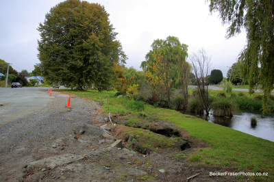
A photograph captioned by Paul Corliss, "Avon River at Kibblewhite Reserve".

A photograph captioned by Paul Corliss, "Avonside and Retreat Roads post earthquake".

A photograph captioned by Paul Corliss, "Avon River at Kibblewhite Reserve".

A photograph captioned by Paul Corliss, "Avonside and Retreat Roads post earthquake".

A photograph captioned by Paul Corliss, "Avonside and Retreat Roads post earthquake".

A photograph of a road over the Greendale fault line which has shifted laterally.

A photograph of a road over the Greendale fault line which has shifted laterally.

A photograph of a road over the Greendale fault line. The road has shifted laterally.

A photograph of a damaged footpath on Cambridge Terrace.

A photograph of a damaged footpath on Cambridge Terrace.

A photograph of a damaged footpath on Cambridge Terrace.

A photograph of lateral shifting in a rural road indicating the location of the Greendale fault line.

A photograph of volunteers from the Wellington Emergency Management Office, examining the lateral shifting of a rural road.

A photograph of lateral shifting in a rural road indicating the location of the Greendale fault line.

A photograph of lateral shifting in a rural road indicating the location of the Greendale fault line.

A photograph of a damaged footpath captioned by Paul Corliss, "Avonside and Retreat Roads post earthquake".

Rolleston, South Island, NZ
Photograph captioned by BeckerFraserPhotos, "Oxford Terrace in the Avon Loop area showing the lateral spread on the river banks".

Photograph captioned by BeckerFraserPhotos, "An aerial photograph showing extreme examples of lateral spreading on the banks of the River Avon near the rowing clubs at Kerrs Reach".

Photograph captioned by BeckerFraserPhotos, "Avonside Drive - there are a number of fissures of this depth about".

A very large woman stands wedged between two rows of concrete pillars eating a huge cream bun. She says 'Christmas fare protection... it helps prevent lateral spread!' Context - overeating at Christmas and lateral spreading, which is associated with liquefaction and tends to occur near streams and waterways as the soil mass moves towards them. Reference to the Christchurch earthquake of 4th September 2010.
Quantity: 1 digital cartoon(s).

A photograph of a damaged footpath on Cambridge Terrace.

Photograph captioned by Fairfax, "Christchurch Earthquake. Damage in Richmond. Locals explore extreme lateral spreads in River Road".

Photograph captioned by Fairfax, "Christchurch Earthquake. Damage in Richmond. Locals explore extreme lateral spreads in River Road".

Photograph captioned by Fairfax, "Christchurch Earthquake. Damage in Richmond. Locals explore extreme lateral spreads in River Road".

Photograph captioned by Fairfax, "Christchurch Earthquake. Damage in Richmond. Locals explore extreme lateral spreads in River Road".

Photograph captioned by Fairfax, "Christchurch Earthquake. Damage in Richmond. Locals explore extreme lateral spreads in River Road".

Photograph captioned by Fairfax, "Christchurch Earthquake. Damage in Richmond. Locals explore extreme lateral spreads in River Road".

Photograph captioned by Fairfax, "Christchurch Earthquake. Damage in Richmond. Locals explore extreme lateral spreads in River Road".

Photograph captioned by Fairfax, "Christchurch Earthquake. Damage in Richmond. Locals explore extreme lateral spreads in River Road".