
A photograph of volunteers from the Wellington Emergency Management Office catering for the staff at the Mainland Foundation Ballpark. The ballpark was set up by Civil Defence as an Emergency Response Centre after the 4 September 2010 earthquake.

Damage to a house in Richmond. Bricks have fallen from a wall, and there is a visible gap between the foundation and the surrounding ground. The photographer comments, "The foundation and a section of the wall of the dining room have shifted and cracked. The dining room floor is very springy".

A photograph of volunteers from the Wellington Emergency Management Office at the canteen set up as part of a temporary Civil Defence headquarters after the 4 September 2010 earthquake. The headquarters was set up the Mainland Foundation Ballpark on Pages Road.

A photograph of the i-SITE Visitor Centre in Kaiapoi. The foundations have lifted at the back of the building giving it a forward lean. Tape has been placed across the footpath and road as a cordon.

A photograph of the earthquake damage to a house on Woodham Road. The house has come off its foundations as the bricks wall have crumbled, spilling onto the footpath in front. Road cones have been placed along the street to warn road users.

A photograph of the i-SITE Visitor Centre in Kaiapoi. The foundations have lifted at the back of the building giving it a forward lean. Tape has been placed across the footpath and road as a cordon.

A photograph of Byron from the Wellington Emergency Management Office taking a phone call in one of the Mainland Foundation Ballpark offices. The ballpark was set up as a Emergency Report Centre by Civil Defence after the 4 September 2010 earthquake.

A photograph of members of the Wellington Emergency Management Office working in an office at the Mainland Foundation Ballpark on Pages Road. The ballpark was set up as an Emergency Report Centre by Civil Defence after the 4 September 2010 earthquake.

A photograph of volunteers from the Wellington Emergency Management Office at the canteen set up as part of a temporary Civil Defence headquarters after the 4 September 2010 earthquake. The headquarters was set up at the Mainland Foundation Ballpark on Pages Road.

A photograph of members of the Wellington Emergency Management Office working in an office at the Mainland Foundation Ballpark on Pages Road. The ballpark was set up as an Emergency Report Centre by Civil Defence after the 4 September 2010 earthquake.

A photograph of members of the Wellington Emergency Management Office working in an office at the Mainland Foundation Ballpark on Pages Road. The ballpark was set up as an Emergency Report Centre by Civil Defence after the 4 September 2010 earthquake.

A photograph of All Right? Campaign Manager Sue Turner (middle), Mental Health Foundation Southern Development Manager Freedom Preston-Clarke (right) and someone else. The photograph was taken at the All Right? Campaign Launch at the Pallet Pavilion.

A photograph of All Right? Campaign Manager Sue Turner (middle), Mental Health Foundation Southern Development Manager Freedom Preston-Clarke (right) and someone else. The photograph was taken at the All Right? Campaign Launch at the Pallet Pavilion.

A photograph of All Right? Campaign Manager Sue Turner (middle), Mental Health Foundation Southern Development Manager Freedom Preston-Clarke (right) and someone else. The photograph was taken at the All Right? Campaign Launch at the Pallet Pavilion.

A worker pouring contrete into the foundation of a temporary classroom on the Ilam Oval.

A photograph of a volunteer laying a foundation for the Life in Vacant Spaces headquarters.

A photograph captioned by BeckerFraserPhotos, "Foundation stones the way Christchurch does them in 2012".

Photograph captioned by BeckerFraserPhotos, "Hereford Street - foundation stone from the building known as Kenton Chambers".

A photograph captioned by BeckerFraserPhotos, "Foundation stone in the chapel of Christ's College, Rolleston Avenue".

A photograph of a map of Christchurch in a temporary Civil Defence headquarters set up at the Mainland Foundation Ballpark after the 4 September 2010 earthquake. Red, green and blue markings on the map indicate where flooding, sand and closures are located. Post-it notes and a key with a tag reading, "Manchester" are attached to the map.

The foundation stone removed from the Church Hall at 165 Papanui Road. The stone reads, "A.D.1902".

A construction site where some ground foundation has been laid down. In the background is a damaged brick property.

Photograph captioned by BeckerFraserPhotos, "Cannon Hill Crescent".

Relates to the three new categories for residential foundation design that have been developed and will be required for repairing and rebuilding homes in Canterbury following the earthquakes of 2010 and 2011. The 'zones' referred to in the cartoon are the colours designated to different degrees of damage to particular areas or buildings in Christchurch after the earthquakes.
Quantity: 1 digital cartoon(s).

Cement is piped from the trucks to the foundations where it is poured into the foundation posts when building the Ilam village.

Cartoon shows a stone foundation that commemorates 'community spirit' after the Christchurch earthquake of February 22 2011.
Quantity: 1 digital cartoon(s).

Cement is piped from the trucks to the foundations where it is poured into the foundation posts when building the Ilam village.

A photograph of students from the Student Volunteer Army and Entré with a sign reading, 'Churchill Park'.
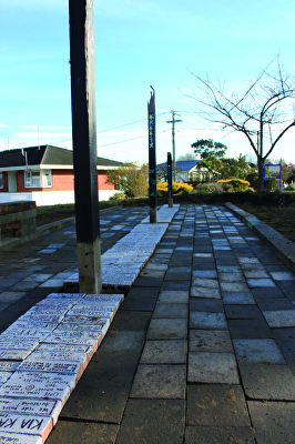
A photograph of bricks laid as a pathway in Churchill Park. Each brick has a message written on it.

A photograph of bricks forming a playing square of Christchurch: A Board Game. The bricks show a picture of ChristChurch Cathedral, and read, "ChristChurch Cathedral. Skip church, move to Ferry Rd".