
A photograph of people examining a section of road lying on the Greendale Fault line which has large cracks caused by the 4 September 2010 earthquake. Police tape and cones have been used to close off the road.

A photograph of a fence on the Greendale Fault line which has shifted considerably due to the 4 September 2010 earthquake. Police tape and cones have been placed across the road to close it off.

A photograph of people examining a section of road lying on the Greendale Fault line which has large cracks caused by the 4 September 2010 earthquake. Police tape and cones have been used to close off the road.

An incomplete infographic showing a proposed fault rupture avoidance zone where the Alpine Fault runs under Franz Joseph township.

A photograph of a section of road lying on the Greendale Fault line which has shifted considerably and cracked due to the 4 September 2010 earthquake. In the distance, police tape and cones have been used to close off the road.

A map of earthquake events in Canterbury.

A map showing the location of a study dating historic earthquakes on the Alpine Fault.

A photograph of cracks across a road in Canterbury caused by the 4 September 2010 earthquake.

An infographic describing research into historic earthquakes on the Greendale Fault.

A map of the tectonic plate boundary of the alpine fault in New Zealand.

Photograph captioned by Fairfax, "Aerial shot of the fault line that ruptured, causing Saturday's 7.1 earthquake. The fault line running through a woolshed".

Photograph captioned by Fairfax, "Aerial shot of the fault line that ruptured, causing Saturday's 7.1 earthquake. The fault line streaks through a farm".

Photograph captioned by Fairfax, "Aerial shot of the fault line that ruptured, causing Saturday's 7.1 earthquake. The fault line running through a paddock".

One oblong perspex covered 3-D model of the fault plains associated with the 4 September 2010 Darfield earthquake; top of the model also acts as a map overlay. Geologists continue to study the 4 September 2010 earthquake and consider it is likely to have been a complex event with several faults rupturing simultaneously. This model provides one ...

Telegraph Road was a straight road before the recent 7.1 magnitude earthquake. The fault ran right through here and now the road has a dramatic kink in it.

Photograph captioned by Fairfax, "Aerial shot of the fault line that ruptured, causing Saturday's 7.1 earthquake. The fault line running through a woolshed near West Melton".

A photograph of a crack in a field indicating the Greendale faultline. A mobile phone has been placed beside the crack as a size reference.

A photograph of a crack in a field indicating the Greendale faultline. A mobile phone has been placed beside the crack as a size reference.
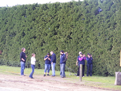
A photograph of volunteers from the Wellington Emergency Management Office taking photographs of the lateral shifting and cracks in a road after the 4 September 2010 earthquake.

Photograph captioned by Fairfax, "Aerial shot of the fault line that ruptured, causing Saturday's 7.1 earthquake. The fault line ripped across a road which has been repaired".

Photograph captioned by Fairfax, "Aerial shot of the fault line that ruptured, causing Saturday's 7.1 earthquake. The fault runs between the house and garage of this property".

Photograph captioned by Fairfax, "Aerial shot of the fault line that ruptured, causing Saturday's 7.1 earthquake. The fault runs between the house and garage of this property".

Photograph captioned by Fairfax, "Aerial shot of the fault line that ruptured, causing Saturday's 7.1 earthquake. The fault runs between the house and garage of this property".

Photograph captioned by Fairfax, "Aerial shot of the fault line that ruptured, causing Saturday's 7.1 earthquake. Locals walk across a paddock showing jagged scars from the fault line".

Photograph captioned by Fairfax, "Aerial shot of the fault line that ruptured, causing Saturday's 7.1 earthquake. Locals walk across a paddock showing jagged scars from the fault line".

Two huge wrestlers, one representing 'Port Hills fault' and the other 'Greendale fault' struggle together over a broken Christchurch. Another wrestler, representing 'Other faults' appears in the distance yelling 'Is it my turn yet?' Context - Christchurch has now had three major earthquakes and thousands of aftershocks. It now appears likely that the Christchurch quakes resulted from activity on a fault extending directly eastward from the Alpine fault that remained unknown until last year, says Roger Musson, a seismologist at the British Geological Survey in Edinburgh. The new fault first came to light last September (4th) when a stronger but less calamitous quake shook Darfield, 40 kilometres west of Christchurch. Musson says the latest quake (Feb 22, 2011) probably resulted from an eastward continuation of activity on the same fault. "It has probably not moved for tens of thousands of years, so lots of strain built up," says Musson. The third major quake happened on 13th June 2011. (New Scientist - February 22, 2011)
Quantity: 1 digital cartoon(s).

Photograph captioned by Fairfax, "Aerial shot of the fault line that ruptured, causing Saturday's 7.1 earthquake. The fault line runs across the paddocks and road and into the distance".

Photograph captioned by Fairfax, "Aerial shot of the fault line that ruptured, causing Saturday's 7.1 earthquake. The fault line runs across the paddocks and road and into the distance".

Photograph captioned by Fairfax, "Aerial shot of the fault line that ruptured causing Saturday's 7.1 earthquake. The fault line went in between the house and garage of this property".

Photograph captioned by Fairfax, "Aerial shot of the fault line that ruptured, causing Saturday's 7.1 earthquake. The fault line runs across the paddocks and road and into the distance".