
Containers protecting the street from vulnerable buildings on Madras Street.

A black and white historic photograph of John Anderson and his foreman, Mr A. Kirk, standing outside the foundry at the back of the Andersons' building, [ca. 1900].

Canterbury Brewery, St Asaph Street, Christchurch.
File reference:
CCL-2012-02-20-CanterburyBrewery-February-2012 DSC_144.JPG
From the collection of Christchurch City Libraries.

Canterbury Brewery, St Asaph Street, Christchurch.
File reference:
CCL-2012-02-20-CanterburyBrewery-February-2012 DSC_147.JPG
From the collection of Christchurch City Libraries.

Canterbury Brewery, St Asaph Street, Christchurch.
File reference:
CCL-2012-02-20-CanterburyBrewery-February-2012 DSC_142.JPG
From the collection of Christchurch City Libraries.

Canterbury Brewery, St Asaph Street, Christchurch.
File reference:
CCL-2012-02-20-CanterburyBrewery-February-2012 DSC_146.JPG
From the collection of Christchurch City Libraries.

Canterbury Brewery, St Asaph Street, Christchurch.
File reference:
CCL-2012-02-20-CanterburyBrewery-February-2012 DSC_143.JPG
From the collection of Christchurch City Libraries.

Canterbury Brewery, St Asaph Street, Christchurch.
File reference:
CCL-2012-02-20-CanterburyBrewery-February-2012 DSC_145.JPG
From the collection of Christchurch City Libraries.

Road works on the corner of Hereford Street and Colombo Street.
One landscape colour digital photograph taken on 25 February 2011 showing earthquake damage on western side of Oxford Street, Lyttelton Taken from the footpath looking downhill from Lyttelton Main School. The buildings visible (from the foreground) are: London Street Restaurant; Bells Pharmacy; Maritime House (McKay - ISS Limited, Shipping Ag...

One landscape colour digital photograph taken on 27 April 2011 showing the demolition of the premises of Ground Delicatessen on the corner of Canterbury and London Streets. The photograph is taken from Canterbury Street. The site formerly occupied by Ground Delicatessen was made available for a Gap Filler initiative called the Lyttelton Petanqu...

A photograph of street art at the Addington Saleyards, taken before the Canterbury earthquakes.

A photograph of street art at the Addington Saleyards, taken before the Canterbury earthquakes.

A photograph of street art at the Addington Saleyards, taken before the Canterbury earthquakes.

A photograph of street art at the Addington Saleyards, taken before the Canterbury earthquakes.

A photograph of street art at the Addington Saleyards, taken before the Canterbury earthquakes.

A photograph of street art at the Addington Saleyards, taken before the Canterbury earthquakes.

Aftermath of September 4th Earthquake in Canterbury NZ. Bridge Street, South Brighton, Christchurch.

Aftermath of September 4th Earthquake in Canterbury NZ. Bridge Street, South Brighton, Christchurch.

Hargood Street (23.02.2011)
Woolston
Christchurch
Canterbury
New Zealand
© 2011 Phil Le Cren
Photo Taken With:
Canon EOS 1000D
+ Canon EF/EF-S lenses
+ 10.1 effective megapixels
+ 2.5-inch TFT color LCD monitor
+ Eye-level pentamirror SLR
+ Live View shooting.
+ EOS Built-in Sensor cleaning system
+ Wide-area 7 poin...

Photograph captioned by BeckerFraserPhotos, "26 Canterbury Street, Lyttelton".
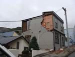
One landscape colour digital photograph taken on 25 February 2011 showing earthquake damage to houses on the western side of Canterbury Street between London and Winchester Streets. The photograph shows large sections of a brick firewall which have fallen onto the roof of the neighbouring house. The close proximity of buildings in Lyttelton led...

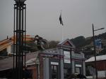
One landscape colour digital photograph taken on 25 February 2011 showing damage to the Lyttelton Police Station on Sumner Road and London Street. Photograph taken looking west from St Davids Street. In December 2011, the New Zealand Police decided that the Lyttelton Police Station would be demolished. The building, which opened in 1882 was re...

One landscape colour digital photograph taken on 26 May 2013 on Winchester Street, Lyttelton. The photograph is taken looking south from the site of the Catholic Church of St Joseph the Worker to the site of the Anglican Church of the Most Holy Trinity. Visible are the removed top of the bell tower and porch. The damaged vicarage is at the weste...

Workers survey a street in Avonside where there are large cracks, piles of liquefaction dug up from people's houses, fenced off portions of the street and an army vehicle parked, after the September 4th earthquake.

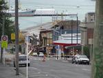
Madras Street. Built 1903 by Alfred William Fielder. The handsome facade is visible here: www.historic.org.nz/TheRegister/RegisterSearch/RegisterRe...

One landscape colour digital photograph taken on 25 February 2011 showing earthquake damage to the Catholic Church of St Joseph the Worker in Winchester Street Lyttelton. Photograph shows the eastern side of the church. Photograph taken from St Davids Street. The earthquake damaged eastern wall of the Catholic Church of St Joseph the Worker sho...
One landscape colour digital photograph taken on 15 April 2011 showing the demolition of Coastal Living Design Store on London Street. In Christchurch's Central Business District many of the high profile demolitions took place out of public view in the Red Zone. By contrast, the demolitions on London Street after the 22 February 2011 earthquake...

A view from the corner of Durham and Armagh Streets to the historic Canterbury Provincial Council buildings. The building's clock tower has collapsed onto Armagh Street, and the street has been closed off with wire fencing and road cones.