
Post the earthquakes land has sunk and in this case the track is below high tide level. It would have been at least 500mm above the highest tide level prior to the recent earthquakes that started on 04/09/10.

A view after the 6.3 magnitude earthquake in Christchurch 22 February 2011.
Corner of Barbadoes and Kilmore Streets. So sad to see history die - both buildings and business.

All this is "red zone" after the earthquakes and has to be demolished. The roof of my "old" house (now owned by the government) can be seen between the third and fourth river-side houses.

St Marys Church

A view after the 6.3 magnatude quake hit Christchurch 22 February 2011.
These buildings were demolished this afternoon 09 March 2011 - Gone!

The former Government Life building in Christchurch's Cathedral Square will be demolished. On my walk around the city May 21, 2014 Christchurch New Zealand.
www.stuff.co.nz/the-press/news/christch...

20131228_6786_1D3-97 Twelve Days of Christmas (part 1)
The NG building on Madras Street was given the go ahead to repair earthquake damage, which the owners did at some expense, Now, the government want this land to build a central city stadium, so there is a protest on the windows set to the Christmas song the Twelve Days of Christmas.
12 mi...

20160415_0039_1D3-40 The Wobbly Jetty - 1 (106/366) [Explored]
The South New Brighton jetty was rebuilt a couple of years before the 2010 and 2011 earthquakes wrecked it. Then, it was straight, level and all railings on left side were intact. Was closed to the public for about four years but is open now.
#7221

Friday 22 February 2013.
Official Supported Site for River of Flowers: Horseshoe Lake
Riverbank on Lake Terrace Road, opposite the bus stop between Oregon and Tangmere Places
Hosted by: Burwood Primary School and Community.
File reference:
CCL-2013-02-22-River-of-FlowersDSC_03401.JPG
From the collection of Christchurch City Libraries.
...

Scavenger Hunt 101 - SH 8 (abandoned building or ruin)
The ruins/remains of what was the third highest building in Christchurch, pre earthquakes, the Price Waterhouse Coopers building in Armagh Street. At 76.3 metres ( 21 floors) the demolition has left the basement (now flooded) and these supports.
Just one of many photos from Christchurch ...

None

These have been thrown in the Avon River

All red zoned and it looked like no one is living anywhere in Culver Place. All awaiting demolition.

None
Went for a drive down to South New Brighton/Southshore after work today to see what interesting birds I could find on the Estuary (godwits, skuas, terns etc), but passing Jellico Street, I saw this. T-Rex the seismic survey truck from the University of Texas that is visiting the city (first time out of USA). Weighs 30 tonne and from the marks o...

The Cranmer Court demolition started today in Christchurch. The 1876 building was originally a Normal School and was in a derelict state in the early 1980s when it was rescued and converted into apartments. The heritage-listed building was red-stickered after the February 2011 earthquake.

Closeup of the Grand Chancellor showing the south eastern corner, which is where it has slumped and broken and is now leaning in that direction.
I note that they have taken some equipment out of the roof, you can see daylight through the gaps on the other side. The broken windows are also clearly visible with curtains hanging in some of them. ...

There are occasional sewerage spills into the Avon River while all the sewer and road repairs are carried out. This rock wall was level and well above high tide level prior to the eathquakes. All the houses that can been seen here (except for those on the distant Port Hills) are in the suburban "red zone" and are still to be demolished.

20131231_8509_EOS M-22 Forsyth Barr building with remains of PWC just behind the green fence (across river)
Another city walk around, this time with my brother-in-law from Auckland. Also went to the Quake City exhibition in the city organised by the Canterbury Museum. First fine day for a while.
#4506

20131214_6268_1D3-24 Where once stood houses (Day 348/365)
The area beside the lower Avon River in New Brighton of Evans Avenue and Admirals Way has been cleared of houses and boundary fences (there were between 15 and 20 houses on this block) , fully fenced with post and wire and "spray on" grass applied.
These were all red zone properties a...

A very different looking Castle Rock to what was there pre earthquakes.

Cathedral of the Blessed Sacrameny aka Christchurch Basilica

None

See next photo

External stairs on the Forsyth Barr building in Christchurch. Portions of the internal stairwell collapsed during the earthquake of February 22nd 2011, necessitating use of various means of getting people out of the building. Was the fourth highest building in the city pre earthquakes, but it's future is uncertain. Was for sale "as is, where ...

Awaiting the demolition ball! See the hole punched in by the neighbouring building (now demolished) during the February 22 2011 earthquake. This building is leaning to the north (left) while it's now demolished neighbour was leaning to the south (right).
All because the crap land gave way underneath!

None

None
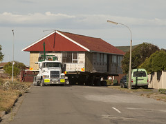
Moving from the Bexley "Red Zone" to?
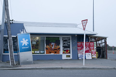
20120321_2397_1D3-47 Beachcomber Dairy
Corner of New Brighton Road and Rawson Street, New Brighton. This diary is inside the suburban red zone and will probably be demolished some time in the future. See how the earthquakes have moved the footpath - the post and phone box used to stand straight! This is one of the Teleccom Wi-Fi hotspot boo...