
20130312_4425_1D3-150 South New Brighton boardwalk track [Explored]
Damaged in the earthquakes, now with more bends and not level as it was before.
Selected for Explore. #306 12/05/13
#3402

A photograph looking south down Madras Street towards Latimer Square. Remains of a partially-demolished building can be seen on the right.

A photograph looking south down Colombo Street from near the Cashel Street intersection. Rubbish skips line the right side of the road.

A photograph looking south down Chancery Lane from Gloucester Street. Shops on either side are closed and dead leaves litter the footpath.

A photograph looking south down Chancery Lane from Gloucester Street. Shops on either side are closed and dead leaves litter the footpath.

An aerial photograph looking south-east over Cathedral Square with Rydges Hotel in the bottom centre, and the site of Clarendon Towers.

A photograph of damaged buildings. The photograph is captioned by BeckerFraserPhotos, "A view of the south side of Lichfield Street".

Photograph captioned by BeckerFraserPhotos, "Looking from north-east to south-west across the Arts Centre, Christ's College and Hagley Park".

Photograph captioned by BeckerFraserPhotos, "The Crossing on the south-east corner of Cashel and Colombo Streets (formally Beath's department store)".

A photograph captioned by BeckerFraserPhotos, "Long summer grass surrounds the fallen stone on the south side of ChristChurch Cathedral".

A photograph of damaged buildings. The photograph is captioned by BeckerFraserPhotos, "A view of the south side of Lichfield Street".

Liv Kivi sitting outside the UC QuakeBox container in New Brighton. The container was parked south of the New Brighton Library.

Photograph captioned by BeckerFraserPhotos, "The Holiday Inn Hotel on the south-east corner of High and Cashel Streets, under deconstruction".

A photograph of damaged buildings. The photograph is captioned by BeckerFraserPhotos, "A view of the south side of Lichfield Street".

The city side of the South Brighton bridge. Approaches on both sides will need extensive work before this bridge can re-open.

The South New Brighton jetty has been closed for 3 or 4 years (fenced off) then the fence was removed and it was "open", but nothing has happened to it since the earthquakes, but it is closed again now, although it looks like a home made sign!
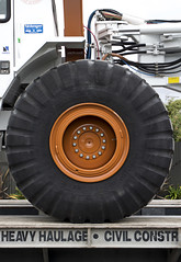
Went for a drive down to South New Brighton/Southshore after work today to see what interesting birds I could find on the Estuary (godwits, skuas, terns etc), but passing Jellico Street, I saw this. T-Rex the seismic survey truck from the University of Texas that is visiting the city (first time out of USA). Weighs 30 tonne and from the marks o...
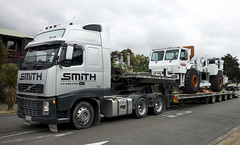
Went for a drive down to South New Brighton/Southshore after work today to see what interesting birds I could find on the Estuary (godwits, skuas, terns etc), but passing Jellico Street, I saw this. T-Rex the seismic survey truck from the University of Texas that is visiting the city (first time out of USA). Weighs 30 tonne and from the marks o...

The flooded Bexley Wetlands, now about 1 - 1.5metre below pre earthquake level. The short length of fence (mid ground) was on the "river track" that the council closed about three years ago. The whole track in this view is now under about 500mm water at high tide.
The main track in front of the houses was, prior to earthquakes, below the leve...

Went for a drive down to South New Brighton/Southshore after work today to see what interesting birds I could find on the Estuary (godwits, skuas, terns etc), but passing Jellico Street, I saw this. T-Rex the seismic survey truck from the University of Texas that is visiting the city (first time out of USA). Weighs 30 tonne and from the marks o...

The jetty in the South New Brighton Domain was rebuilt a few years ago. It was straight and level till the earthquakes. Has been closed for 2½ years now.

The jetty in the South New Brighton Domain was rebuilt a few years ago. It was straight and level till the earthquakes. Has been closed for 2½ years now. The shags like it though!
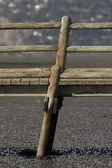
The jetty in the South New Brighton Domain was rebuilt a few years ago. It was straight and level till the earthquakes. Has been closed for 2½ years now.

Went for a drive down to South New Brighton/Southshore after work today to see what interesting birds I could find on the Estuary (godwits, skuas, terns etc), but passing Jellico Street, I saw this. T-Rex the seismic survey truck from the University of Texas that is visiting the city (first time out of USA). Weighs 30 tonne and from the marks o...

Aftermath of September 4th Earthquake in Canterbury (area covers Christchurch City), NZ. Cracks alongside Avon river.

20100904_3322_1D3-200 Bridge Street bridge, Christchurch earthquake
South Brighton Bridge. See the gap between the abutment and the bridge itself (just to right of lower person).

The city side of the South Brighton bridge. Approaches on both sides will need extensive work before this bridge can re-open.
Bridge opened for traffic less than a week later, but still (23/09) has 30kmh speed restriction.

20160415_0039_1D3-40 The Wobbly Jetty - 1 (106/366) [Explored]
The South New Brighton jetty was rebuilt a couple of years before the 2010 and 2011 earthquakes wrecked it. Then, it was straight, level and all railings on left side were intact. Was closed to the public for about four years but is open now.
#7221

20160415_0044_1D3-38 The Wobbly Jetty - 2
The South New Brighton jetty was rebuilt a couple of years before the earthquakes wrecked it. Was closed to the public for about four years but is open now.
#7222

A photograph looking south down Montreal Street, taken from the intersection of Worcester Street. In the distance, the street has been cordoned off.