
A crane sits beside the sewage treatment ponds in Bromley. In the distance can be seen large piles of liquefaction silt. The photographer comments, "Bromley sewage treatment ponds, under repair".

A house in Richmond being demolished. Looking through a gap where an external wall has been removed, the interior of a room can be seen. The photographer comments, "The end of 393 River Rd".

A view down Victoria where a section of the road has been cordoned off. In the background is Christchurch Casino and the Crowne Plaza Hotel can be partially seen on the right.

The building that housed the New Zealand College of Early Childhood Education and Antiqueworld has been cordoned off. Spray painted marks left by USAR after it was checked can still be seen.

A digger at the site of the CTV Building. In the background, the elevator shaft can still be seen.

Two diggers at the site of the CTV Building. In the background, the elevator shaft can still be seen.

An aerial view of Christchurch a week after the 22 February 2011 earthquake. The CTV site can be seen.

An aerial view of Lyttelton a week after the 22 February 2011 earthquake. St John's Church can be seen.

An aerial view of Christchurch a week after the 22 February 2011 earthquake. The Knox Church can be seen.

An aerial view of Christchurch a week after the 22 February 2011 earthquake. Christ Church Cathedral can be seen.

Two diggers at the site of the CTV Building. In the background, the elevator shaft can still be seen.

Two diggers at the site of the CTV Building. In the background, the elevator shaft can still be seen.

A view down Manchester Street, looking south. The road is noticably buckled, and rubble from damaged buildings can be seen beyond the cordon fence. The photographer comments, "Today I ... went for a walk along the cordon to the north of Christchurch CBD which runs about one street back from Bealey Avenue. The soldiers manning the cordon seemed happy for me to take photos but I couldn't see much of the city from the barrier ... what you can see shows there's obviously a lot of damage. The roads are swollen and raised in many place. The once flat CBD will now feature plenty of hills as well as natural traffic calming features".

Photograph captioned by BeckerFraserPhotos, "Looking from Lichfield Street across cleared land to the Twisted Hop. The statue of the banana palm can be seen".

A rubbish truck collects rubbish from the red bins along Rocking Horse Road in Southshore. The uneven surface of the road can be seen, with water pooling in the foreground.

A photograph looking north down Colombo Street, from the intersection of Armagh Street. In the distance, rubble from the partially-collapsed Winnie Bagoes building can be seen on the road.

A photograph looking east down Hereford Street from the intersection with Manchester Street. In the distance, an excavator can be seen filling a truck with the rubble from a demolished building.

A photograph of buildings on Oxford Terrace with damage to their awnings. USAR codes can be seen spray-painted on the fence of the Bangalore Polo Club.

A photograph looking west down Gloucester Street, taken from the Cambridge Terrace intersection. Wire fencing can be seen along both sides of the footpath, keeping people away from the buildings.

An aerial photograph looking south over the Christchurch CBD centred on Colombo Street. The Town Hall and beginnings of Gap Filler's Pallet Pavilion can be seen to the bottom left.

A photograph looking south down Manchester Street from the intersection with Armagh Street. Badly-damaged buildings can be seen along the street, as well as the Hotel Grand Chancellor in the distance.

A photograph looking south down Manchester Street. Damaged buildings on the right have been cordoned off with wire fencing. In the distance, the Hotel Grand Chancellor Hotel can be seen.

A photograph of the remains of the McKenzie & Willis building on Tuam Street. Part of the shipping containers which are stacked on the road can be seen to the left.

A photograph looking south down Manchester Street. People are walking along the road looking at earthquake damage. The Octagon Live building and the Holiday Inn can be seen to the right.

Emergency personnel searching for people trapped in the collapsed Canterbury Television Building on Madras Street. Smoke can be seen rising from the ruins, which have been on fire.
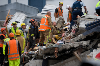
Emergency personnel searching for people trapped in the collapsed Canterbury Television Building on Madras Street. Smoke can be seen rising from the ruins, which have been on fire.

Damage to the Lyttelton Port. In the background the HMNZS Canterbury can be seen, just returned from a trip to Wellington to resupply.

An aerial view of Christchurch a week after the 22 February 2011 earthquake. The Christchurch Art Gallery can be seen.

Broken gutters on the Christ Church Cathedral where the roof has fallen away. Damage to the brickwork can also be seen to the right.

An aerial photograph looking south west over the CBD. Latimer Square can be seen in the centre right of the photograph. To the left, the Transitional Cathedral is being constructed.