
A photograph of damaged buildings on Manchester Street, taken from the intersection of High Street. On the left, stacked shipping containers are holding up the remaining facade of the Excelsior Hotel building.

Photograph captioned by Fairfax, "Major earthquake hits Christchurch. Collecting water from a water tanker on Kingsford Street are Callum McDowell (left) and Jamie McDowell".

Photograph captioned by Fairfax, "Performers for quake from Kaikoura. From left, Philip Gillard, Aaron Cooper, Chris Lidgard, Neil Harding, Phil Smith, Olivia Hall, James Baker and Kerry".

The front side of the Cathedral with the rose window removed and bracing supporting the wall. The broken tower can be seen to the left and fencing placed around the outside of the building.

Damage to a building on Colombo Street. Beside it is a sign that says 'Footpath closed Please use alternative route'. Ongoing demolition work and street cordons in Christchurch mean that gardens are left and becoming overgrown.

View of the corner of Montreal and Victoria Street. In the background is a vacant lot left by buildings that has been demolished, and on the right is Gordon Smith & Sons fruit and vegetable shop.

Flowers blooming in a vacant site left by the demolition of a building at the corner of Worcester Street and Stanmore Road. On the wall at the back are the words 'Do Not Demo!!'.

The Botanic Gardens, in the background is part of the Peacock Fountain, Christchurch I-site in a portacom on the left and the Art Centre. In the foreground is a wheelbarrow with some gardening equipment.

The Avon river, with some cordon fence around Our City O-Tautahi, that was in the former Municipal Chambers visible on the left and the central Police station in the background between the trees.

Looking down Worcester Street with Our City-O-Tautahi with bracing on its front facade on the left, behind it is Rydges, the Grant Thornton Building in the middle back, and the Claredon Towers on the right.

A black and white historic photograph of the intersection of Colombo and High Streets, with the Fishers' building visible on the left, [ca. 1884].

A photograph of a tag on the side of a building on Ferry Road. The tag reads, "Move". Another tag is visible to the left.

Photograph captioned by Fairfax, "Earthquake cleanup in Dallington. Transport Minister Steven Joyce (2nd from left) and other officials inspecting dammage on Avonside drive at Dallington".

A photograph looking west down Tuam Street. C1 Espresso can be seen on the right. On the left, construction hoarding and scaffolding surrounds the badly-damaged McKenzie & Willis building.

A photograph of members of the IHC Christchurch Earthquake Reflection Group. From left to right are Andrew Dever, Kerry Horsham, Andrew Oswin, Michael Krammer, Rosanne Parrish, Chris Farrow, and Gary Buchanan.

A photograph of members of the IHC Christchurch Earthquake Reflection Group. From left to right are Andrew Dever, Kerry Horsham, Andrew Oswin, Michael Krammer, Rosanne Parrish, Chris Farrow, and Gary Buchanan.

A photograph of a room in the Diabetes Centre. Several filing cabinets have opened and files have fallen off the bookcases on the left and right, spilling onto the floor and furniture.

Liquefaction and flooding in Waitaki Street, Bexley. The photographer comments, "Due to liquefaction and broken drains the water left by the liquefaction stayed in the area for over a week".

Buildings seen through the cordon fence from Cathedral Square. From left to right are MFL House, the Forsyth Barr building, the PriceWaterhouseCoopers building, the Camelot Hotel and the Cathedral Square Police Station.

A view down Worcester Boulevard. Some parts of the Arts Centre are visible on the left, and in front is the sculpture "Reasons for Voyaging", a collaboration between Canterbury sculptor, Graham Bennett and architect, David Cole.

A photograph of a lipstick print left by artist Audrey Baldwin on the Kissing Booth during her performance at the Addington Fun Fair.
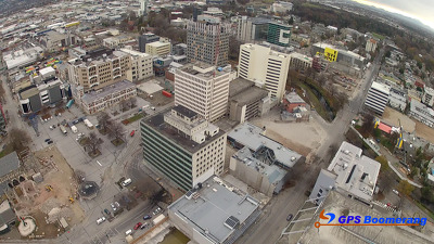
A snapshot from GPS Boomerang's SmartBird flight over the Christchurch red zone on 5 June 2012, looking over Gloucester Street with the Cathedral visible on the bottom left and Oxford Terrace to the right.

Photograph captioned by Fairfax, "Andrew (left) and Roger Kelso from Westende Jewellers are moving into a new premises after the earthquake destroyed their Manchester Street store".

An aerial photograph looking south west over the Christchurch CBD with the Avon River visible to the left and Hagley Park in the distance.

A snapshot from GPS Boomerang's SmartBird flight over the Christchurch red zone on 23 December 2012, looking over Durham Street with Gap Filler's Pallet Pavilion to the left, on the site of the Crowne Plaza Hotel.

A photograph looking north up Colombo Street from near the intersection with Tuam Street. Building rubble litters the left side of the road, as well as the right in some places in the distance.

A man making notes on a map of the Botanic Gardens outside the Robert McDougall Art Gallery. Cracks can be seen in the footpath to his left.

Lane Perry and students make a chess board in a demolition space in Sydenham, Colombo St, 30.11.11 01- left to right Elliot Faulkner UC, Lane Perry UC, Oleg Sheremetor UC and Coralie Winn, Gap Filler.

A photograph of the back of Gough House on Hereford Street with a pile of rubble in front. To the left, the back of Shand's Emporium can be seen.

Paintwork on the side of a building in High Street exposed by the demolition of the adjoining building. The photographer comments, "I'm fascinated by the 'shadows' left behind on the sides of buildings by their neighbours".