
Looking down High Street from Colombo Street. A public walkway down Colombo Street to a small viewing area in the Square was opened up for a few weekends to allow the public to see inside the Red Zone.

Looking down High Street from Colombo Street. A public walkway down Colombo Street to a small viewing area in the Square was opened up for a few weekends to allow the public to see inside the Red Zone.

Looking down High Street from Colombo Street. A public walkway down Colombo Street to a small viewing area in the Square was opened up for a few weekends to allow the public to see inside the Red Zone.
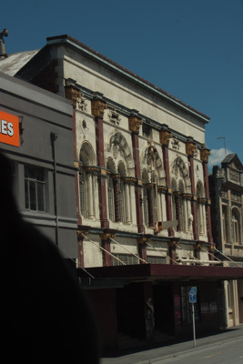
For the first time in November 2011, Christchurch residents finally had the opportunity to see the earthquake-damaged city centre on the Red Zone bus tours organised by CERA. Damage to the Odeon Theatre can be seen out the window.
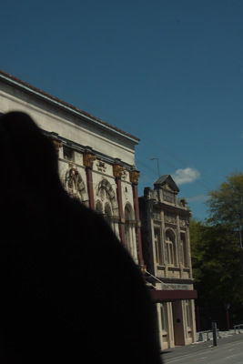
For the first time in November 2011, Christchurch residents finally had the opportunity to see the earthquake-damaged city centre on the Red Zone bus tours organised by CERA. Damage to the Odeon Theatre can be seen out the window.

For the first time in November 2011, Christchurch residents finally had the opportunity to see the earthquake-damaged city centre on the Red Zone bus tours organised by CERA. Damage to buildings on Cashel Street can be seen out the window.

For the first time in November 2011, Christchurch residents finally had the opportunity to see the earthquake-damaged city centre on the Red Zone bus tours organised by CERA. The Regent Theatre dome which has been removed from the building.

For the first time in November 2011, Christchurch residents finally had the opportunity to see the earthquake-damaged city centre on the Red Zone bus tours organised by CERA. Looking into Cathedral Square, the Regent Theatre dome can be partially seen.

Damage to the Cathedral, and its lawn growing wild. A public walkway through to a small viewing area in the Square was opened up for a few weekends to allow the public to see inside the Red Zone.

The door of Knox Presbyterian Church on Bealey Avenue. A red sticker has been taped to the door, indicating that the building is unsafe to enter. USAR codes have also been spray painted below.

A photograph of the earthquake damage to the corner of Woodham Road and Avonside Drive. There are large cracks in the road, and flooding and liquefaction. Wire fencing and road cones have been placed around parts of the road that are unsafe. Two signs reading, "Road closed" and, "No entry" can be seen at the entrance to Avonside Drive.

The Windsor Hotel, on the corner of Montreal Street and Armagh Street. The building was red-stickered after the September 2010 earthquake and demolished after the February 2011 earthquake. Beside the hotel, construction has begun on a modern, tilt-slab building.

Fallen potplants and jumbled paving bricks outside Stewart Dawsons in Cashel Mall. A public walkway down Colombo Street to a small viewing area in the Square was opened up for a few weekends to allow the public to see inside the Red Zone.

Weeds growing through the paving outside the old Post Office building in Cathedral Square. A public walkway through to a small viewing area in the Square was opened up for a few weekends to allow the public to see inside the Red Zone.

A photograph of an earthquake-damaged house in Christchurch. The walls on the side of the house have crumbled and the bricks have damaged the fence. A red sticker on the front window indicates that the building is unsafe to enter.

For the first time in November 2011, Christchurch residents finally had the opportunity to see the earthquake-damaged city centre on the Red Zone bus tours organised by CERA. Looking down the new Re:Start Mall as the bus goes down Colombo Street.

Photograph captioned by BeckerFraserPhotos, "Kilmore Street on the left. The red-sided building is 818 Colombo Street. The white-sided building with the four rows of square windows is 115-119 Kilmore Street across Colombo Street".

An aerial photograph of the Christchurch City Council Civic Offices and surrounding buildings. The photograph has been captioned by BeckerFraserPhotos, "The River Avon runs through this photograph and marks the western edge of the red zone".

The collapsed chimney of a property on Robson Avenue in Avonside. It has fallen on to the property's front lawn as a result of the 4 September 2010 earthquake, and the section of roof it fell from has been weather proofed with a red tarpaulin.

The collapsed chimney of a property on Robson Avenue in Avonside. It has fallen on to the property's front lawn as a result of the 4 September 2010 earthquake, and the section of roof it fell from has been weather proofed with a red tarpaulin.

Looking east down Hereford Street from Colombo Street. A public walkway down Colombo Street to a small viewing area in the Square was opened up for a few weekends to allow the public to see inside the Red Zone. The partially demolished Grand Chancellor is visible in the background.

Looking down High Street from Colombo Street. A public walkway down Colombo Street to a small viewing area in the Square was opened up for a few weekends to allow the public to see inside the Red Zone. The partially demolished Grand Chancellor is visible in the background.

Warped bike stands and liquefaction silt on the corner of High, Colombo and Hereford streets. A public walkway down Colombo Street to a small viewing area in the Square was opened up for a few weekends to allow the public to see inside the Red Zone.

For the first time in November 2011, Christchurch residents finally had the opportunity to see the earthquake-damaged city centre on the Red Zone bus tours organised by CERA. The podium which formerly held the Godley statue. Behind is the Regent Theatre dome which has been removed from the building.

A view down Worcester Street towards the Regent Theatre building. Tiles have fallen away from the Regent Theatre's red dome. In the foreground the Clarendon Hotel can be seen, with a large crack where the facade has pulled away from the rest of the building.

A red-stickered building on Canterbury Street in Lyttelton. The building's facade has been propped up with timber, steel and concrete block bracing, and one of its windows has been weather proofed with plywood. Wire fencing has been place around the building as a cordon.

Notices on the doors of The Cook Shop on the ground level of the Strategy building, Montreal Street. The sign on the left reads, "Danger, your house has a red placard, do not enter". The sign to the right indicates that the building is unsafe to enter.

St John's Presbyterian Church on Winchester Street in Lyttelton. The ground around the church is strewn with masonry that has fallen from the church's walls and collapsed tower. The building's front door has been red-stickered and a sign that reads "No entry" is stuck to it.

A photograph of some simple street art on a concrete wall. The artwork depicts a masked boy with red hair, nestled between the colourful letters of tag writing. An excavator from Mount Grey Downs Limited and some stacked concrete slabs are in the foreground.

The remains of lunches are still visible in the window seats of this sushi shop on Colombo Street. A public walkway down Colombo Street to a small viewing area in the Square was opened up for a few weekends to allow the public to see inside the Red Zone. People in the walkway are reflected in the window.