
Wednesday 2 May 2012.
File reference: CCL-2012-05-02IMG_2228
From the collection of Christchurch City Libraries.

Wednesday 2 May 2012.
File reference: CCL-2012-05-02IMG_2229
From the collection of Christchurch City Libraries.

Wednesday 2 May 2012.
File reference: CCL-2012-05-02IMG_2230
From the collection of Christchurch City Libraries.

Wednesday 2 May 2012.
File reference: CCL-2012-05-02IMG_2227
From the collection of Christchurch City Libraries.
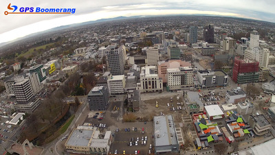
A snapshot from GPS Boomerang's SmartBird flight over the Christchurch red zone on 5 June 2012, looking over Hereford Street with the Re:Start container mall visible in the bottom right. The Cathedral can be seen in the middle right, Oxford Terrace to the left.

A snapshot from GPS Boomerang's SmartBird flight over the Christchurch red zone on 23 December 2012, looking over Hereford Street with the Re:Start container mall visible in the bottom right, Oxford Terrace to the left. The buildings at the end of Cashel Street near Oxford Terrace have been demolished.

None

Photograph captioned by BeckerFraserPhotos, "Big nibbler begins to work at the rear of Gough House, Hereford Street".

A photograph captioned by BeckerFraserPhotos, "The intersection of Hereford and Manchester Streets, looking north east".

Photograph captioned by BeckerFraserPhotos, "Inside Mans Bakery and Cafe, 138 Hereford Street. The food is still in the cabinets after 16 months".

Photograph captioned by BeckerFraserPhotos, "164-170 Hereford Street is used as a concrete recycling and crushing area".

A photograph captioned by BeckerFraserPhotos, "The intersection of Hereford and Manchester Streets, looking south west".

A photograph captioned by BeckerFraserPhotos, "The intersection of Hereford and Manchester Streets, looking north west".

A photograph captioned by BeckerFraserPhotos, "The intersection of Hereford and Manchester Streets, looking south east".

Building rubble and liquefaction on the footpath outside the former Public Library on the corner of Hereford Street and Cambridge Terrace.

Building rubble and liquefaction on the footpath outside the former Public Library on the corner of Hereford Street and Cambridge Terrace.

Building rubble and liquefaction on the footpath outside the former Public Library on the corner of Hereford Street and Cambridge Terrace.

A photograph of an excavator on an empty building site between Cashel Street and Hereford Street. Two cranes can be seen in the distance.

Photograph captioned by BeckerFraserPhotos, "197-203 Hereford Street viewed from Latimer Square - Demolition site of Avonmore House".

The intersection of Colombo and Gloucester Streets looking north-west.

An aerial photograph captioned by BeckerFraserPhotos, "High, Colombo, and Hereford Streets intersection".

A photograph captioned by BeckerFraserPhotos, "A view looking north west from the intersection of Manchester Street and Hereford Street".

A photograph captioned by BeckerFraserPhotos, "A view looking north west from the intersection of Manchester Street and Hereford Street".

A photograph of ornate metalwork from a heritage building, lying on the footpath. The photograph is captioned by BeckerFraserPhotos, "Decorative elements, Hereford Street".

Photograph captioned by BeckerFraserPhotos, "A view looking west along Hereford Street from Colombo Street".

A photograph captioned by BeckerFraserPhotos, "A view looking north east from the intersection of Manchester Street and Hereford Street".

A digital copy of a pen and ink and watercolour painting by Raymond Morris, titled, 'TSB Building, corner Colombo and Hereford Streets'.

A photograph of an excavator on an empty building site between Cashel Street and Hereford Street. Two cranes can be seen in the distance.

A photograph of St Elmo Courts on the corner of Montreal and Hereford Streets. There are large cracks between the windows.

The intersection of Colombo and Gloucester Streets looking south-west.