
Members of the Royal New Zealand Air Force Air Security team preparing to evacuate Christchurch rest home residents affected by the 22 February 2011 earthquake.

The front page graphic for a feature marking the anniversary of the 22 February 2011 earthquake. The feature is titled, "The year that was".
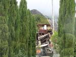
One landscape colour digital photograph taken on 25 February 2011 showing the damage to the former Anglican Vicarage on Ripon Street Lyttelton. Taken from the footpath. Architect The sense of loss felt when confronted with the collapse or demolition of an historic building is compounded when that building is also a home. While the community sees...

One music CD entitled 'Te Huaki Puanaki presents Ōtautahi Christchurch Rise Up' featuring three songs in response to the 22 February 2011 earthquake. This music CD titled ‘Te Huaki Puanaki presents Ōtautahi Christchurch Rise Up’ symbolically records the changes, emotions and challenges faced by the people of Canterbury following the 2010-2011 e...

One landscape colour digital photograph taken on 28 February 2011 showing the plume of water from a broken water main. The plume appears to be in the vicinity of the Bridle Path. Photograph taken looking west from the corner of Canterbury and Ripon Streets. Repairing infrastructure following the Canterbury Earthquakes has proved to be a complex...

The front page graphic for a feature marking the anniversary of the 22 February 2011 earthquake. The feature is titled, "Beyond the call".

The contents page for the Your Weekend section of The Press, featuring an editorial about the anniversary of the 22 February 2011 earthquake.

One blue soft cover children’s book titled 'Quaky Cat' with text by Diana Noonan and colour illustrations by Gavin Bishop. The earthquakes and accompanying aftershocks in Canterbury proved to be a very frightening experience, especially for children. This book was written in response to the 4 September 2010 earthquake to help children understan...

Photograph captioned by Fairfax, "Damage from the February 22nd earthquake in Christchurch. A message from the Beckenham Baptist Church on Colombo Street".

Photograph captioned by Fairfax, "Damage from the February 22nd earthquake in Christchurch. A message from the Beckenham Baptist Church on Colombo Street".

Photograph captioned by Fairfax, "Damage from the February 22nd earthquake in Christchurch. PGG-Wrightson building on Cambridge Terrace where people are trapped".

Photograph captioned by Fairfax, "Damage from the February 22nd earthquake in Christchurch. Retaining wall and roof damage at 26 Hackthorne Road, Cashmere".

Photograph captioned by Fairfax, "Damage from the February 22nd earthquake in Christchurch. Retaining wall and roof damage at 26 Hackthorne Road, Cashmere".

Photograph captioned by Fairfax, "Damage from the February 22nd earthquake in Christchurch. Chimney repair work at a house on Hackthorne Road, Cashmere".

One oblong perspex covered 3-D model of the fault plains associated with the 4 September 2010 Darfield earthquake; top of the model also acts as a map overlay. Geologists continue to study the 4 September 2010 earthquake and consider it is likely to have been a complex event with several faults rupturing simultaneously. This model provides one ...

North Hagley Park, Christchurch, New Zealand.
Tens of thousands turned out today to mark the one year anniversary of the devastating earthquake that struck the city at 12.51pm on 22 February, 2011.
185 people lost their lives.
file.stuff.co.nz/stuff/12-51/
Took 4 pa...

One landscape colour digital photograph taken on 15 April 2011 showing the demolition of the Volcano Restaurant, the Lava Bar, Lyttelton Fisheries and Coastal Living Design Store on the corner of London and Canterbury Streets. Also visible is a placard advertising a Community Briefing to be held on 17 April 2011. In Christchurch's Central Bu...

One portrait colour digital photograph taken on 25 February 2011 showing damage to the Old Post Office Building on the Corner of Norwich Quay and Oxford Street. Architect The archaeological investigation of the site of the old Lyttelton Post Office uncovered evidence of Maori settlement in the area including a midden, fire places and an adze. Th...

One landscape colour digital photograph taken on 25 February 2011 showing damage to the Norton Buildings on Oxford Street. The photograph shows part of the first floor of the building and the façade collapsed onto the ground floor and out onto the street. The photograph was taken from St Davids Street looking west. Also visible in the photogra...

One portrait colour digital photograph taken on 25 February 2011 showing the damaged façade of a two storey shop on Norwich Quay. The brick wall has completely fallen off the top storey and crushed a car parked on the footpath outside. Damage to the Lyttelton Hotel is visible to the left of the photo. The design of many older commercial build...

One portrait colour digital photograph taken on 25 February 2011 showing damage to the Plunket Rooms on Sumner Road. Also visible in the photograph are the rear of the former Library and Fire Station, 2 London Street and the eastern end of The Church of the Most Holy Trinity. When the Lyttelton Plunket Rooms were demolished in July 2012, archae...
One landscape colour digital photograph taken on 27 April 2011 showing damage to the Old Post Office Building on the corner of Norwich Quay and Oxford Street. The old Telegraph office located beside the Old Post Office and the Timeball Station are also visible. Architect As Lyttelton's first main street, Norwich Quay was the site of many early g...
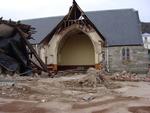
One portrait colour digital photograph taken on 25 September 2011 showing the demolition of the Catholic Church of St Joseph the Worker in Winchester Street Lyttelton. Photograph shows the Transepts, Sanctuary. The damage from the June 2011 aftershocks led to the demolition of the St Joseph Church 146 years after its opening in June 1865. The L...

One landscape colour digital photograph taken on 25 February 2011 showing damage to the Lyttelton Police Station on Sumner Road and London Street. Photograph taken looking west from St Davids Street. In December 2011, the New Zealand Police decided that the Lyttelton Police Station would be demolished. The building, which opened in 1882 was re...

The New Zealand Fire Department's headquarters in Latimer Square. After the 22 February 2011 earthquake, emergency service agencies set up their headquarters in Latimer Square.

Photograph captioned by Fairfax, "Damage from the February 22nd earthquake in Christchurch. View north on Colombo Street in Sydenham. Damaged shops and cars".

Photograph captioned by Fairfax, "Damage from the February 22nd earthquake in Christchurch. View north on Colombo Street in Sydenham. Damaged shops and cars".

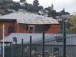
Photograph captioned by Fairfax, "Damage from the February 22nd earthquake in Christchurch. Damaged stone church on the corner of Colombo and Brougham Streets".

Photograph captioned by Fairfax, "Damage from the February 22nd earthquake in Christchurch. Damaged stone church on the corner of Colombo and Brougham Streets".

Photograph captioned by Fairfax, "Damage from the February 22nd earthquake in Christchurch. View north on Colombo Street in Sydenham. Damaged shops and cars".