
A photograph of the Wellington Emergency Management Office team deployed in Christchurch after the 4 September 2010 earthquake.
Sadly the days are numbered after the 6.3 quake that hit Christchurch 22 February 2011! You can see the blue streel strengthening on the tower from the earthquake on 4 September 2010. Also if you look closely you can see the cracks that have determained its fate! Press L.
One landscape colour digital photograph taken on 26 May 2013 on the corner of Norwich Quay and Canterbury Street, Lyttelton. The photograph shows the Mitre Hotel surrounded by temporary fencing. Three years after the 2010-2011 earthquakes there are still many uncertainties about which buildings can or will be retained. These buildings, or parts...

Damaged facade? That's the decorative mural of this restaurant located on Manchester Street in Christchurch!

This building at the corner of Barbadoes Street / St Asaph Street was so badly damaged in the magnitude 7.1 earthquake that struck Christchurch on Saturday 4 September 2010 that it had to be demolished

Heaving and subsidence on the faultline left scars where the magnitude 7.1 earthquake on Saturday 4 September 2010 originated.

The historic Provincial Hotel at the Barbadoes Street / Cashel Street corner has been cordoned off for fear of collapse; aftermath of the magnitude 7.1 earthquake that struck Christchurch on Saturday 4 September 2010.

One landscape colour digital photograph taken on 26 May 2013 showing the southern cliffs of Godley Head. Taken from the middle of the shipping channel. Some earthquake damage to the cliffs is visible. There were several major rock falls along the coastal cliffs near Christchurch and Lyttelton Harbour. At Godley Head these caused damage to the W...

Falling gable of the Anglican Community of the Sacred Name building left a gaping hole in the roof in the magnitude 7.1 earthquake that hit Christchurch on 4 September 2010. The chimney would have toppled as well had it not been braced.
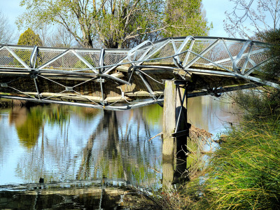
The badly twisted Medway Street footbridge. The photographer comments, "The September 4th 2010 earthquake in Christchurch was so violent that the banks of the Avon River moved towards each other. This footbridge being metal had to twist sideways to release the pressure of being pushed from both river banks. It looked like it had been wrung out like a wet towel".

A colour photograph of the west facade of the Excelsior Hotel, taken after the September 4th earthquake.

Tension cracks at least 300 mm deep, on the previously unknown faultline from which the Saturday 4 September 2010 earthquake originated.

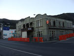
One landscape colour digital photograph taken on 16 June 2011 showing the eastern skyline of Lyttelton without the tower of the Timeball Station and Signal Mast. Part of the ground floor remains visible. The Holcim Cement Silos and Lyttelton Port of Christchurch log storage yard are visible in the foreground. Photograph taken from Oxford Street...

One landscape colour digital photograph taken on 26 May 2013 showing the southern cliffs of Godley Head, taken from the middle of the shipping channel. Some earthquake damage to the cliffs is visible. There were several major rock falls along the coastal cliffs near Christchurch and Lyttelton Harbour. At Godley Head these caused damage to the ...

Photograph captioned by Fairfax, "Cabinet Minister for Social Development, Paula Bennett in Christchurch after the September 4th earthquake".

Photograph captioned by Fairfax, "The historic Duvauchelle pub has been badly damaged after September 4th earthquake".

Photograph captioned by Fairfax, "The historic Duvauchelle pub has been badly damaged after September 4th earthquake".

Photograph captioned by Fairfax, "The historic Duvauchelle pub has been badly damaged after September 4th earthquake".

Castle Rock above Heathcote, showing damage (and two very large pieces in the foreground) that came down during the 7.1 quake on 4th September.

This house along Bealey Ave lost its chimney stack in the magnitude 7.1 earthquake that struck Christchurch on Saturday 4 September 2010.

Time stands still on the Science Museum clock tower as a poignant reminder of the moment the trembler struck Christchurch in the early hours of Saturday 4 September 2010.

Time stands still on the Science Museum clock tower as a poignant reminder of the moment the trembler struck Christchurch in the early hours of Saturday 4 September 2010.

Time stands still on the Science Museum clock tower as a poignant reminder of the moment the trembler struck Christchurch in the early hours of Saturday 4 September 2010.

One landscape colour digital photograph taken on 25 February 2011 showing earthquake damage to the Lyttelton Timeball Station. Also visible is damage to some of the houses in the foreground such as temporarily patched holes in roofs where chimneys have fallen. Architect The Lyttelton Timeball Station was completed in 1876. Its function was to p...
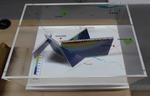
One oblong perspex covered 3-D model of the fault plains associated with the 4 September 2010 Darfield earthquake; top of the model also acts as a map overlay. Geologists continue to study the 4 September 2010 earthquake and consider it is likely to have been a complex event with several faults rupturing simultaneously. This model provides one ...

One trophy made from a can attached to a wooden base issued to SCIRT as a thank you for participating in Canstruction Christchurch. Features a custom printed label which celebrates teamwork in place of the usual nutritional information.

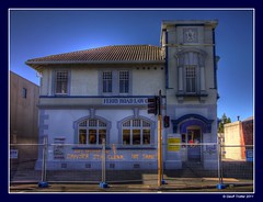
A colour photograph of the Fisher's Building, seen from the corner of Lichfield and High Streets. The photograph was taken before the 4 September 2010 earthquake.

Shop parapet toppled in the magnitude 7 earthquake in Christchurch on Saturday 4-9-2010. This building was condemned and demolished on 9 September 2010.

The latest (but temporary) tourist attraction in mid-Canterbury! This was the previously unknown faultline where the Saturday 4 September 2010 earthquake originated.

One landscape colour digital photograph taken on 19 November 2011 showing earthquake repairs being undertaken to the Irish Pub on the south side of London Street. The Lyttelton streetscape has changed dramatically from its pre-earthquake appearance and will continue to change as new buildings are erected on empty sections. In this photograph Lo...