Search
found 4602 results
All Right? Resources: Screensaver 2
Images, UC QuakeStudies
An image designed for use as a downloadable screensaver. The image depicts an 'All Rightie' in a fluorescent vest standing by a road cone and gazing at the night sky. The image reads, "When was your last moment of wonder? Sometimes the quietest moments can really change our perspective".
WEMO ERT Set 1 - March 2011 - Photograph 128
Images, UC QuakeStudies
A photograph looking west down Cashel Street towards the Bridge of Remembrance. Rubble from earthquake-damaged buildings is piled on the road in the distance. Wire fencing has been placed in front of a seating area to the left and around a building in the distance.
Ray Whelan WEMO Photograph 32
Images, UC QuakeStudies
A photograph of volunteers from the Wellington Emergency Management Office working at the reception in Cowles Stadium on Pages Road. The stadium was set up by Civil Defence as temporary accommodation for citizens displaced by the 4 September 2010 earthquake. One of the volunteers is holding a cat in a carrier.
Natalie Kerschner WEMO Photograph 064
Images, UC QuakeStudies
A photograph of a stretcher with blankets and pillows sitting in the corner of Cowles Stadium. In the background, boxes full of supplies from the Red Cross and wrapped-up mattresses can be seen. The stadium served as temporary accommodation for refugees from the 4 September earthquake.
All Right? Social Media: Facebook Timeline Image 57
Images, UC QuakeStudies
A photograph of an All Right? billboard on Waltham Road. The billboard depicts two 'All Righties' harvesting a giant pumpkin and carrots. It reads, "What good things are you growing?" All Right? posted the photograph on their Facebook page on 6 September 2013 at 1:03pm.
WEMO ERT Set 1 - March 2011 - Photograph 14
Images, UC QuakeStudies
A photograph of members of the Wellington Emergency Management Office Emergency Response Team and the Red Cross, standing on the corner of Lichfield and Manchester Street. In the background an excavator is parked on the road. Behind the excavator is a block of earthquake-damaged buildings.
WEMO ERT Set 3 - February 2011 - Photograph 145
Images, UC QuakeStudies
A photograph of the earthquake damage to Charlie B's Backpackers on Madras Street. The front of the building has collapsed, the bricks and other rubble spilling onto the road and footpath in front. Many of the walls inside the top storey of the building are now hanging loose from the ceiling.
Christchurch Mail Image: Anna Price 2010:10:01 09:32:40
Images, UC QuakeStudies
Photograph captioned by Fairfax, "Chris Lin and his wife Caleen Xue at the door of their cool store safe where they slept for three weeks after the 4 September earthquake to guard what was left of their stock, while their teenage children rented a single room in a house up the road for their safety".
BeckerFraserPhotos February 2011 photograph 185
Images, UC QuakeStudies
Scaffolding that has been constructed on the Manchester Street face of the Octagon Live Restaurant (formerly Trinity Church), which is being repaired. Masonry has fallen from one of the building's gables, and the resultant gap has been weather proofed with plywood and a tarpaulin. The site has been enclosed in a safety fence that cuts off one lane of the road.
BeckerFraserPhotos July 2011 photograph 385
Images, UC QuakeStudies
A photograph captioned by BeckerFraserPhotos, "Avonside Girls High School sign". The sign reads, "This site is closed but the school is open. Avonside Girls High School has been temporarily relocated to Burnside High School, 151 Greers Road, Burnside 8053. Please do not enter this site - earthquake-damaged buildings".
BeckerFraserPhotos December 2011 photograph 2319
Images, UC QuakeStudies
A photograph captioned by BeckerFraserPhotos, "Moira Fraser standing beside a bus stop sign in Bower Avenue (near the intersection with New Brighton Road) to demonstrate how much this pole has sunk into the ground. Note the marker with two round luminous spots which is at ground level and compare it with the next photo".
Christchurch Press Image: Carys Monteath 2010:09:06 07:45:46
Images, UC QuakeStudies
Photograph captioned by Fairfax, "Christchurch Earthquake. University student Sam Johnson organised through Facebook students to go into the suburbs to help residents clean up after Saturday morning's earthquake. They gathered in Halswell to help residents clean up the silt from their properties. James Litchwark (L) and James Wigzell shovel dirt from 2A Larsons Road, Halswell".

Digital Photograph: Earthquake damage to the London Street Restaurant on L…
Images, Canterbury Museum
One landscape colour digital photograph taken on 27 April 2011 showing damage to the London Street Restaurant. Photograph taken looking west from the intersection of London Street with Oxford Street and Sumner Road. Adaptability and quick thinking has become a key part of business survival in post earthquake Canterbury. The owner of this bui...

River of Flowers - Te Waitohi Maumahara
Images, eqnz.chch.2010
Friday 22 February 2013. Official Supported Site for River of Flowers: Horseshoe Lake Riverbank on Lake Terrace Road, opposite the bus stop between Oregon and Tangmere Places Hosted by: Burwood Primary School and Community. File reference: CCL-2013-02-22-River-of-FlowersDSC_03401.JPG From the collection of Christchurch City Libraries. ...
IMG_2269
Images, eqnz.chch.2010
The farmer swore that his fence was erected in a straingt line, but mother nature had other ideas! Aftermath of the Saturday 4 September 2010 magnitude 7.1 earthquake at the previously unknown faultline along which the quake originated.

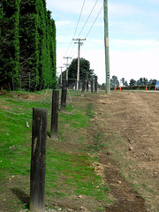
IMG_2268
Images, eqnz.chch.2010
The farmer swore that his hedge was planted in a straingt line, but mother nature had other ideas! Aftermath of the Saturday 4 September 2010 magnitude 7.1 earthquake at the previously unknown faultline along which the quake originated.

IMG_2270
Images, eqnz.chch.2010
The farmer swore that his fence was erected in a straingt line, but mother nature had other ideas! Aftermath of the Saturday 4 September 2010 magnitude 7.1 earthquake at the previously unknown faultline along which the quake originated.

Going in!
Images, eqnz.chch.2010
Working at getting things out of the Victoria Square before it is demolished. www.stuff.co.nz/the-press/news/christchurch-earthquake-20... What I found on my walk around the city January 15, 2014 Ch...
X Marks the Spot
Images, eqnz.chch.2010
What I found on a walk around the city Christchurch November 20, 2013 New Zealand. www.isaactheatreroyal.co.nz/ en.wikipedia.org/wiki/2011_Christchurch_earthquake
WEMO ERT Set 1 - March 2011 - Photograph 13
Images, UC QuakeStudies
A photograph of members of the Wellington Emergency Management Office Emergency Response Team standing on the intersection of Manchester and Lichfield Streets. In the background is the Majestic Theatre. Piles of rubble from earthquake-damaged buildings has been piled on the road below the building.
Looking Towards the Red Zone
Images, UC QuakeStudies
A view down Beresford Street in New Brighton, looking west towards the city at sunset. The photographer comments, "On the other side of the Avon river from New Brighton is the Bexley red zone. Here numerous earthquake damaged streets of houses will be flattened due to it being to uneconomical in the current climate to repair the land to be suitable for housing. There is a campaign at the moment to try and convert all this red zone land, which is mainly adjacent to the Avon river to a giant park".
New Zealand Defence Force photograph 688
Images, UC QuakeStudies
Damage to the Lyttelton Hotel on Norwich Quay. The top of the building has crumbled, bringing the roof down with it. Bricks have fallen on the awning and all along the footpath. Wire fencing and road cones have been used to create a cordon around the building.
BeckerFraserPhotos February 2011 photograph 181
Images, UC QuakeStudies
Scaffolding that has been constructed on the Manchester Street face of the Octagon Live Restaurant (formerly Trinity Church), which is being repaired. Masonry has fallen from one of the building's gables, and the resultant gap has been weather proofed with plywood and a tarpaulin. The site has been enclosed in a safety fence that cuts off one lane of the road.
Photograph by Neil Macbeth 161
Images, UC QuakeStudies
Members of the public speaking with police officers on the corner of Durham Street and Armagh Street in the aftermath of the 22 February earthquake. On the right the timber section of the historic Provincial Council Chambers can be seen, including the clock tower which has collapsed onto the road. Armagh Street leading into the city has been cordoned off by red tape.
Photograph by Neil Macbeth 638
Images, UC QuakeStudies
The west-side of the Arts Centre along Rolleston Avenue near the entrance to the Botanic Gardens. Wire fencing and road cones have been placed around the building as a cordon. To the left, a crane is parked next to the building. The spire has been removed and braced on the footpath to limit damage.
Christchurch Press Image: Robyn Edie 2010:09:10 14:40:45
Images, UC QuakeStudies
Photograph captioned by Fairfax, "Gorge Road School held a 'Red & Black' themed dress day and a gold coin donation (which they made into a coin trail) to raise funds for earthquake-stricken Canterbury. Pictured with their coins are Logan Marshall (5) on the left and Aaron Hart (6), with school pupils in behind. The fifty-pupil school managed to raise $136.00".
QuakeStory Photo 368
Images, UC QuakeStudies
A photograph submitted by Scott Thomas to the QuakeStories website. The description reads, "The picture is of St Martins, a suburb just 2 minutes drive up the street from my place. The photo does not do it justice but this road was like the moon, it used to be flat and it is wet due to burst pipes. Photo taken shortly after the 22 Feb 2011 earthquake".
QuakeStory Photo 373
Images, UC QuakeStudies
A photograph submitted by Scott Thomas to the QuakeStories website. The description reads, "The two separate piles of dirt outside on the street from mine and the 5 other townhouses I share my driveway with. In the distance you can see rubble on the ground and if you look carefully you can make out the bumps where the energy released has warped the road. Taken 28 February 2011.".
Photograph by Neil Macbeth 646
Images, UC QuakeStudies
A view across Worcester Street in Linwood to a block of shops showing severe damage after the 22 February 2011 earthquake. The businesses include Talon Arms and Wick's Fish. Masonry and structural components from the buildings has collapsed onto the footpath and road. A sign in front of Talon Arms has been spray painted with the words, "Guns gone".
BeckerFraserPhotos April 2011 photograph 052
Images, UC QuakeStudies
A view down London Street in Lyttelton. The road has been closed to traffic because of unstable and damaged buildings in the area. In the background is the Empire Hotel on London Street in Lyttelton. Bracing has been placed on the front of the building to keep it together and limit further damage from aftershocks. The building has been cordoned off with fencing.