
A photograph of a damaged building in Lyttelton.

A photograph of cordon fences around the damaged Knox Church.

A photograph of a damaged building. The photograph is captioned by Paul Corliss, "Norwich Quay, Lyttelton".

A photograph captioned by Paul Corliss, "Barbadoes Street/Tuam street. Earthquake 4th of September 2010".

A photograph of the warped Medway Street Bridge.

A photograph of the warped Medway Street Bridge.

A photograph captioned by Paul Corliss, "Barbadoes Street/Tuam street. Earthquake 4th of September 2010".

A photograph captioned by Paul Corliss, "Trade Union Centre building, corner of Madras and Armagh Streets".

A photograph of a humorous sign reading, "Warning! No pot holes next 400 m". The photograph captioned by Paul Corliss, "Just before intersection of Kilmore St with Fitzgerald Avenue".

A photograph of a humorous sign reading, "Warning! No pot holes next 400 m". The photograph captioned by Paul Corliss, "Just before intersection of Kilmore St with Fitzgerald Avenue".

A photograph captioned by Paul Corliss, "Mobil station reconstruction, corner Bealey Avenue and Barbadoes Street".

A photograph captioned by Paul Corliss, "Redzoned houses between Wattle Drive and Anzac Drive".

A photograph captioned by Paul Corliss, "Opawa Bridge remediation".

A photograph of the warped Medway Street Bridge.

A photograph of a damaged building in Lyttelton.

A photograph of a humorous sign reading, "Warning! No pot holes next 400 m". The photograph captioned by Paul Corliss, "Just before intersection of Kilmore St with Fitzgerald Avenue".

A photograph captioned by Paul Corliss, "Opawa Bridge remediation".

A photograph of the damaged Cranmer Courts buildings. The damaged gables are supported by straps and bracing.

A photograph captioned by Paul Corliss, "Carlton corner, post 22 February earthquake".

A photograph of rocks fallen from a cliff face. The photograph is captioned by Paul Corliss, "Redcliffs and Sumner".

A photograph of the earthquake damage to a group of shops on the corner of Barbadoes Street and Edgeware Road. The second storey of the shops has collapsed, and the bricks have fallen to the footpath, taking the awnings with them. Police tape and road cones have been placed around the buildings as a cordon.
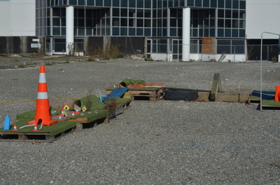
Pallet Golf', a Gap Golf course on a the site of a demolished building. It has been built by Gap Filler to look like a journey through Christchurch. A plastic road cone as well as mini road cones, road signs, tunnels and rivers can be seen. The course has been built using green felt, wooden pallets, tyres, planks of wood and bricks.

A photograph of members of the Wellington Emergency Management Office Emergency Response Team walking down Lichfield Street towards the intersection of Madras Street. There is rubble from several earthquake-damaged buildings on both sides of the road. Plastic fences and road cones have been placed on the street as cordons.

A photograph of the earthquake damage to a group of shops on the corner of Barbadoes Street and Edgeware Road. The second storey of the shops has collapsed, and the bricks have fallen to the footpath, taking the awnings with them. Police tape and road cones have been placed around the buildings as a cordon.

A photograph looking north up Manchester Street from the intersection with Cashel Street. Police tape and road cones have been placed across the street with a sign reading, "Road closed". In the background, members of the public can be seen walking along the street. Wire fencing in the distance has been used to make a cordon before Hereford Street .

Reinforcement steel protrudes from a bank which is supporting a walkway on Sumner Road. The area has been cordoned off with road cones and security fencing.

Photograph captioned by BeckerFraserPhotos, "Wainoni Road (here it is classified as residential green zone)".

Photograph captioned by BeckerFraserPhotos, "Wainoni Road (here it is classified as residential green zone)".

Photograph captioned by BeckerFraserPhotos, "Wainoni Road (here it is classified as residential green zone)".

A road cone marks a large crack in the road on Avonside Drive. Water is visible in the bottom of the crack.