
A photograph captioned by BeckerFraserPhotos, "Canterbury Street, Lyttelton".

Damage to the Canterbury Provincial Council Chambers on Armagh Street.

A photograph captioned by Paul Corliss, "Lyttelton, down Canterbury Street".

A photograph captioned by BeckerFraserPhotos, "Canterbury Street, Lyttelton".

Canterbury Provincial Council and Supreme Court Buildings, Durham Street North.

Canterbury Provincial Council and Supreme Court Buildings, Durham Street North.

The twisted and broken Medway Street bridge. The photographer comments, "The twisted footbridge at the Medway St corner".

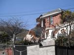
A red-stickered building on Canterbury Street in Lyttelton. The building's facade has been propped up with timber, steel and concrete block bracing, and one of its windows has been weather proofed with plywood. Wire fencing has been place around the building as a cordon.

One landscape colour digital photograph taken on 19 November 2011 showing the site of the Albion Hotel/ Ground Delicatessen. After the demolition of the building the site was used for a Gap Filler initiative called the Lyttelton Petanque Club. The photograph shows the temporary furniture, landscaping and public Petanque court. The site formerl...

One landscape colour digital photograph taken on 19 November 2011 showing the site of the old Lyttelton Library, Council Chambers and Magistrates' Court on the corner of Oxford Street and Sumner Road. At the time of the 22 February 2011 Earthquake the building was in private ownership and was the premises of Moda Fotografica and a private resid...

A graphic showing damage to the Canterbury Provincial Council Buildings.

Cordon on Manchester Street in central Christchurch following the September earthquake.

Damage to buildings on Victoria Street, near the Bealey Avenue intersection.

Bricks on Struthers Lane, fallen from a building on Lichfield Street.

Helicopter Flight over Christchurch
New Zealand

Helicopter Flight over Christchurch
New Zealand
One landscape colour digital photograph taken on 6 September 2011 showing demolition of the former Convent of Our Lady of Mercy. St Mary's School, run by the Sisters of Mercy, was also housed in this building. At the time of the 4 September 2010 earthquake the building was a private residence. Three years after the 2010-2011 earthquakes there a...

A photograph of the Canterbury Provincial Chambers on Durham Street. The building has been cordoned off with wire fencing and the roof covered by plastic sheeting. A crane can be seen to the right.

A photograph of the Canterbury Times and Star Building on Gloucester Street. Bricks and rubble can be seen on the footpath and USAR codes have been spray painted on the doors.

A photograph of the Age Concern Canterbury Building behind a cordon fence on Cashel Street, near Cambridge Terrace. To the right is the site of a demolished building, next to another partially-deconstructed building.

A photograph of two workers walking down Gloucester Street. To the right, the earthquake-damaged Canterbury Times and Star Building can be seen. A car parked in front has been crushed by falling debris.

Emergency personnel gathering on Madras Street outside the collapsed Canterbury Television building. A digger and the Urban Search and Rescue team can be seen searching the rubble.

A photograph of the earthquake damage to the Canterbury Television Building on Gloucester Street. Some of the concrete on the columns has crumbled, revealing the steel reinforcement underneath.

A photograph of the earthquake damage to the Canterbury Television Building on Gloucester Street. Some of the concrete on the columns has crumbled, revealing the steel reinforcement underneath.

One landscape colour digital photograph taken on 25 February 2011 showing earthquake damage to the Anglican Church of The Most Holy Trinity in Winchester Street Lyttelton. Photograph shows the bracing to the northern transept erected after the 4 September 2010 earthquake. Architect The earthquake damaged northern wall of the Anglican Church of t...

One landscape colour digital photograph taken on 25 February 2011 showing damage to the Lodge of Unanimity No 3 at the intersection of St Davids Street and Sumner Road. Original BuildingAdditions The Lodge of Unanimity was established in Lyttelton in 1851. This building was designed in 1878 by Benjamin Woolfield Mountfort, who was a member of th...
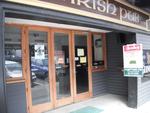
One landscape colour digital photograph taken on 19 November 2011 showing earthquake repairs being undertaken to the Irish Pub on the south side of London Street. The Lyttelton streetscape has changed dramatically from its pre-earthquake appearance and will continue to change as new buildings are erected on empty sections. In this photograph Lo...

One landscape colour digital photograph taken on 19 November 2011 looking east from Norwich Quay from approximately the base of Canterbury Street. Visible in the photograph are the partially deconstructed former Lyttelton Harbour Board Offices, the Holcim Cement Silos, the Oxford Street Railway Overbridge, Lyttelton Port of Christchurch's storag...

One landscape colour digital photograph taken on 27 April 2011 showing the demolition of the Royal Hotel on the corner of Norwich Quay and Canterbury Street. The hotel building shown in this photograph was the third on the site since 1851. It was built in 1916 as a replacement for the first Royal Hotel. The Royal Hotel was established in 1870 a...
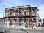
One landscape colour digital photograph taken on 12 April 2011 showing earthquake damage to the Empire Hotel on London Street. The photograph shows the façade of the hotel supported by the framework installed to brace the building after the 4 September 2010 earthquake. Also visible on the fencing in the foreground is the advertising placard for...