
Search
found 468 results
Digital Photograph: The site of the Harbourlight Theatre, London Street, L…
Images, Canterbury Museum
One landscape colour digital photograph taken on 8 June 2011 showing the site of the Harbourlight Theatre on London Street. The site is fenced off, on the fence is the same heart shape which appears tied to a fence in a different part of London Street in 2013.17.39 A white painted wooden cross has been placed in the ground with 24 [street numbe...

Digital Photograph: Earthquake damage to Lyttelton Cenotaph on Simeon Quay…
Images, Canterbury Museum
One landscape colour digital photograph taken on 12 March 2011 showing earthquake damage to the Lyttelton Cenotaph on Simeon Quay. The unstable top of the memorial has been deconstructed and is visible on the surrounding grass, a plastic tarpaulin has been used to cover the top of the newly exposed stonework and a temporary fence has been erecte...

Digital Photograph: Demolition on the Corner of Canterbury and London Stre…
Images, Canterbury Museum
One landscape colour digital photograph taken on 15 April 2011 showing the demolition of the Volcano Restaurant, the Lava Bar, Lyttelton Fisheries and Coastal Living Design Store on the corner of London and Canterbury Streets. Also visible is a placard advertising a Community Briefing to be held on 17 April 2011. In Christchurch's Central Bu...

Digital Photograph: Temporary Repairs to Retaining Wall in Ripon Street, L…
Images, Canterbury Museum
One landscape colour digital photograph taken on 14 July 2011 showing the temporary repairs made to the retaining wall in the middle of Ripon Street. The temporary wall replaces two sections of red stone wall which collapsed in the June 2011 Earthquake. It is made from stacked concrete cubes with coarse fill and the top is covered with black pla...

Digital Photograph: Demolition of the former Library, Council Chambers and…
Images, Canterbury Museum
One landscape colour digital photograph taken on 11 June 2011 showing the demolition of the old Lyttelton Library, Council Chambers and Magistrates' Court on the corner of Oxford Street and Sumner Road. The photograph shows the upper floor of the building being demolished with a high reach digger. At the time of the 22 February 2011 Earthquake...

Digital Photograph: Demolition of Former Canterbury Hotel, corner of Norwi…
Images, Canterbury Museum
One landscape colour digital photograph taken on 14 July 2011 showing the demolition of the former Canterbury Hotel on the corner of Norwich Quay and Oxford Street. At the time of demolition the ground floor was occupied by the Magma Gallery. Also visible in the photograph are the Old Post Office, Lyttelton Takeaways (corrugated iron walls) and ...
Digital Photograph: Earthquake damage to St Joseph's Church, Winchester St…
Images, Canterbury Museum
One portrait colour digital photograph taken on 25 September 2011 showing the demolition of the Catholic Church of St Joseph the Worker in Winchester Street Lyttelton. Photograph shows the Transepts, Sanctuary. The damage from the June 2011 aftershocks led to the demolition of the St Joseph Church 146 years after its opening in June 1865. The L...

Digital Photograph: Former Convent of Our Lady of Mercy, Exeter Street, Ly…
Images, Canterbury Museum
One landscape colour digital photograph taken on 25 September 2011 showing the remaining portion of the former Convent of Our Lady of Mercy. St Mary's School, run by the Sisters of Mercy, was also housed in this building. At the time of the 4 September 2010 earthquake the building was a private residence. The picture shows the perimeter wall, t...

Digital Photograph: Artwork on the Site of the Harbourlight Theatre, Londo…
Images, Canterbury Museum
One portrait colour digital photograph taken on 23 July 2011 showing the artwork by Trent Hiles erected on the site of the Harbourlight Theatre on London Street. The artwork presents part of James K Baxter's poem 'High Country Weather' using the international code of signal flags. The artwork was installed as a Gap Filler project. The artwork r...

Digital Photograph: Partial demolition of the Old Lyttelton Harbour Board …
Images, Canterbury Museum
One landscape colour digital photograph taken on 19 May 2011 showing the partial demolition of the old Lyttelton Harbour Board Offices on the corner of Oxford Street and Norwich Quay. The photograph shows the upper floor of the original part of the building being removed and a temporary roof being constructed over the ground floor. At the time o...
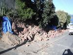
Digital Photograph: Earthquake Damage to Retaining Wall, corner of Oxford …
Images, Canterbury Museum
One landscape colour digital photograph taken on 15 June 2011 showing earthquake damage to the retaining wall on the northeast corner of Oxford and Exeter Streets. The wall was constructed from unreinforced blocks of local red volcanic rock held together with mortar. Retaining walls in Lyttelton were built of unreinforced soft volcanic stone in...

Digital Photograph: Demolition of the former Library, Council Chambers and…
Images, Canterbury Museum
One landscape colour digital photograph taken on 11 June 2011 showing the demolition of the old Lyttelton Library, Council Chambers and Magistrates' Court on the corner of Oxford Street and Sumner Road. The photograph shows the upper floor of the building being demolished with a high reach digger and a jet of water being played on the building ...

Digital Photograph: Demolition of Former Canterbury Hotel, corner of Norwi…
Images, Canterbury Museum
One landscape colour digital photograph taken on 14 July 2011 showing the demolition of the former Canterbury Hotel on the corner of Norwich Quay and Oxford Street. At the time of demolition the ground floor was occupied by the Magma Gallery. Also visible in the photograph are 'Tin Palace' and a former office building which shows repairs made by...

Digital Photograph: Earthquake Damage to Canterbury Hotel and shops. Oxfor…
Images, Canterbury Museum
One landscape colour digital photograph taken on 15 June 2011 showing earthquake damage to the former Canterbury Hotel and adjoining row of shops on Oxford Street. This photograph was taken on Oxford Street and shows the collapsed façade of the row of shops behind safety fencing, the interior of the building is exposed. Shadbolt House is visib...

Digital Photograph: Former Convent of Our Lady of Mercy, Exeter Street, an…
Images, Canterbury Museum
One landscape colour digital photograph taken on 30 June 2011 showing earthquake damage to the former Convent of Our Lady of Mercy and to the Catholic Church of St Joseph the Worker. Photograph taken from St. Davids Street The sense of loss felt when confronted with the collapse or demolition of an historic building is compounded when that bui...

Digital Photograph: Temporary Premises of Lyttelton Bakery, corner of Norw…
Images, Canterbury Museum
One landscape colour digital photograph taken on 16 June 2011 showing the Lyttelton Bakery operating from a portable building on the Corner of Canterbury Street and Norwich Quay. This portable building has been placed on the site of the Royal Hotel. Also visible in the photograph are Shadbolt House and the rear of the buildings on the south side...

Digital Photograph: Temporary Theatre, London Street, Lyttelton
Images, Canterbury Museum
One landscape colour digital photograph taken on 6 September 2011 showing the temporary theatre erected on the site of the Volcano Café on London Street for a production of Macbeth by The Loons Circus Theatre Company. The green canopy supported on shipping containers was used to shelter the audience. The stage area was the demolition site partia...

Digital Photograph: Earthquake damage to the Lyttelton Timeball Station.
Images, Canterbury Museum
One landscape colour digital photograph taken on 16 June 2011 showing the site of the Timeball Station after its collapse. Part of the ground floor remains visible. Photograph taken from Oxford Street Overbridge. Architect The 13 June 2011 earthquakes caused the collapse of the already damaged Lyttelton Timeball Station. After the 22 February ...

Digital Photograph: Partial Demolition of the Old Lyttelton Harbour Board …
Images, Canterbury Museum
One landscape colour digital photograph taken on 16 June 2011 showing the partial demolition of the old Lyttelton Harbour Board Offices on the corner of Oxford Street and Norwich Quay. The photograph shows the temporary roof being constructed over the original ground floor of the building. At the time of the 22 February 2011 earthquake the build...

Digital Photograph: Earthquake damage to Church of the Most Holy Trinity, …
Images, Canterbury Museum
One landscape colour digital photograph taken on 15 June 2011 showing earthquake damage to the Anglican Church of The Most Holy Trinity in Winchester Street, Lyttelton. Photograph shows collapsed roof of the nave and north transept. Photograph taken from the north side of the church. Architect The collapse of the Church of the Most Holy Trinity ...
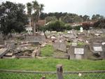
Digital Photograph: Earthquake Damage to Lyttelton Roman Catholic and Diss…
Images, Canterbury Museum
One landscape colour digital photograph taken on 30 June 2011 showing earthquake damage to graves in Lyttelton Roman Catholic and Dissenters (Public) Cemeteries in Reserve Terrace. Most of the headstones and grave surrounds in the photograph show damage. Looking east in the Dissenters (Public) section of the cemetery. The Lyttelton cemeteries a...

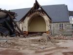
Digital Photograph: Earthquake damage to St John's Church, Winchester Stre…
Images, Canterbury Museum
One landscape colour digital photograph taken on 15 June 2011 showing earthquake damage to the Presbyterian Church of St John in Winchester Street, Lyttelton. Photograph shows the collapsed roof and tower. The photograph is taken from the southern side of the church. Architect The destructive force of the 14 June 2011 earthquakes on buildings in...

Digital Photograph: Earthquake Damage to Lyttelton Roman Catholic and Diss…
Images, Canterbury Museum
One landscape colour digital photograph taken on 30 June 2011 showing signs warning of the danger posed by unstable headstones in Lyttelton Roman Catholic and Dissenters (Public) Cemeteries in Reserve Terrace. Several toppled headstones and collapsed grave surrounds are visible in the photograph. Looking east from the main gate. The Lyttelton c...

Digital Photograph: Earthquake damage to a retaining wall, Lyttelton
Images, Canterbury Museum
One landscape colour digital photograph taken on 30 June 2011 showing earthquake damage to a section of retaining wall in Sumner Road. Plastic sheeting installed to stabilise previous damage and protect from water erosion is visible to the right of the photograph. Also visible in the photograph is a boarded up broken window and temporary safety ...

Digital Photograph: Earthquake damage to Church of the Most Holy Trinity, …
Images, Canterbury Museum
One landscape colour digital photograph taken on 15 June 2011 showing earthquake damage to the Anglican Church of The Most Holy Trinity in Winchester Street, Lyttelton. Photograph shows collapsed roof of the nave and north transept. Photograph taken from the northwest corner of the church. Architect The collapse of the Church of the Most Holy Tr...

Digital Photograph: Earthquake Damage to Canterbury Hotel and shops. Oxfor…
Images, Canterbury Museum
One landscape colour digital photograph taken on 15 June 2011 showing earthquake damage to the former Canterbury Hotel and adjoining row of shops on Oxford Street. This photograph was taken on Oxford Street and shows the collapsed façade of the row of shops behind safety fencing, the interior of the building is exposed. The design of many older...

Digital Photograph: Demolition of former Library and Fire Station, corner …
Images, Canterbury Museum
One landscape colour digital photograph taken on 6 September 2011 showing the demolition of 2 Sumner Road, the former library and fire station. This building was a private residence at the time of its demolition. Photograph taken looking north on Oxford Street. Also visible in the photograph are the Lyttelton Information Centre, an entrance to ...

Digital Photograph: Earthquake damage to St John's Church, Winchester Stre…
Images, Canterbury Museum
One landscape colour digital photograph taken on 15 June 2011 showing earthquake damage to the Presbyterian Church of St John in Winchester Street, Lyttelton. Photograph shows the collapsed roof and tower. The photograph is taken from the southeast corner of the church. Architect St John's Lyttelton was one of the oldest Presbyterian Churches in...

Model: Temple for Christchurch
Images, Canterbury Museum
One model of the Temple for Christchurch with a rectangular base of Jarrah and solid silver conical shapes and wave like walls representing the movement of the 22 February 2011 earthquake. Based on the Temple for Christchurch sculpture that was designed by Hippathy Valentine.
Jennifer Middendorf's Cultural Recovery Centre Photograph 019
Images, UC QuakeStudies
A photograph of a cannon, a lantern, a marble honours board and other large objects from museum collections which are being stored at the Canterbury Cultural Recovery Centre.