Search
found 417 results

BeckerFraserPhotos October 2011 photograph 486
Images, UC QuakeStudies
The intersection of Colombo and High Streets with Hereford Street to the left. The 'Flour Power' statue stands in the centre of the intersection with wire fencing placed around it. Three cranes can be seen in the distance.
Image 5 - Territorial Force
Images, UC QuakeStudies
An image from a Army News March 2011 article titled, "Territorial Force". The image shows members of the Central and Lower North Island Territorial Units clearing silt from a resident's garden in east Christchurch. On the left is Private Quentin Chat of Taranaki, and Corporal Samuel Hatcher of Wellington is on the right.
Photograph by Neil Macbeth 583
Images, UC QuakeStudies
A view down London Street in Lyttelton, looking east from Canterbury Street. To the left, the damaged Volcano Cafe can be seen, with bricks from the side wall still on the road and wire fencing around the building. A road sign reading, "Road closed" has been placed in front of the street ahead.
Photograph by Neil Macbeth 076
Images, UC QuakeStudies
A view of Worcester Boulevard, looking east towards Christ Church Cathedral. Bricks from the front of the building and the tower can be seen on the ground. People are making their way down the street out of the central city. Members of the Emergency Management personnel, in high-visibility vests, can be seen.
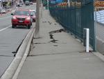
Digital Photograph: Earthquake Damage to Road on Norwich Quay, Lyttelton
Images, Canterbury Museum
One landscape colour digital photograph taken on 25 February 2011 showing earthquake damage to the road, footpath and retaining wall on Norwich Quay. The photograph is taken from below the intersection of Norwich Quay and Canterbury Street looking east along Norwich Quay. Unlike most areas of Christchurch, land damage on the Port Hills was due ...

Digital Photograph: Demolition of the Dry Dock Pump House, Lyttelton
Images, Canterbury Museum
One landscape colour digital photograph taken on 22 March 2011 showing the demolition of the Dry Dock Pump House. Photograph taken from Brittan Terrace looking east over the Inner Harbour. Engineer The brick pump house for the Lyttelton Graving or Dry Dock was damaged in the 22 February 2011 Earthquake. Lyttelton Port of Christchurch decided to...
22 February Earthquake - Photograph 21
Images, UC QuakeStudies
Damage to a house in Richmond. The brick wall is badly cracked and twisted, and some bricks have fallen, exposing the lining paper and framing below. The driveway is cracked and covered in liquefaction. The photographer comments, "These photos show our old house in River Rd and recovery work around Richmond and St Albans. More shaking damage on the east wall of the living room at our house".
22 February Earthquake - Photograph 20
Images, UC QuakeStudies
Damage to a house in Richmond. The brick wall is badly cracked and twisted, and some bricks have fallen, exposing the lining paper and framing below. The driveway is cracked and covered in liquefaction. The photographer comments, "These photos show our old house in River Rd and recovery work around Richmond and St Albans. More shaking damage on the east wall of the living room at our house".
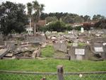
Digital Photograph: Earthquake Damage to Lyttelton Roman Catholic and Diss…
Images, Canterbury Museum
One landscape colour digital photograph taken on 30 June 2011 showing earthquake damage to graves in Lyttelton Roman Catholic and Dissenters (Public) Cemeteries in Reserve Terrace. Most of the headstones and grave surrounds in the photograph show damage. Looking east in the Dissenters (Public) section of the cemetery. The Lyttelton cemeteries a...

Digital Photograph: Earthquake Damage to Lyttelton Roman Catholic and Diss…
Images, Canterbury Museum
One landscape colour digital photograph taken on 30 June 2011 showing signs warning of the danger posed by unstable headstones in Lyttelton Roman Catholic and Dissenters (Public) Cemeteries in Reserve Terrace. Several toppled headstones and collapsed grave surrounds are visible in the photograph. Looking east from the main gate. The Lyttelton c...
Photograph by Neil Macbeth 091
Images, UC QuakeStudies
The damaged Cranmer Centre on the corner of Montreal and Armagh Streets shortly after the 22 February 2011 earthquake. The east wall of the building has crumbled onto the street and a man in a hard hat and high-visibility vest is directing people around it. There is scaffolding on the south side of the building from repair works after the 4 September 2010 earthquake. The gable in the background has also collapsed.
WEMO ERT Set 1 - March 2011 - Photograph 116
Images, UC QuakeStudies
A photograph looking east down Dundas Street. Piles of twisted steel reinforcement have been placed on both sides of the street. Several earthquake-damaged cars, recovered from the Smiths City car park, have been stacked on the left. On the other side of the street is an excavator grapple and bucket. In the distance two excavators are sorting through the rubble.

Digital Photograph: Demolition of the Empire Hotel, London Street, Lyttelt…
Images, Canterbury Museum
One landscape colour digital photograph taken on 19 April 2011 showing the demolition of the Empire Hotel on London Street. The photograph shows the façade of the hotel supported by the framework installed to brace the building after the 4 September 2010 earthquake. A crane is being used to enable the east wall to be demolished by hand to avoid...

Christchurch, NZ - Post Feb Earthquake, 2011
Images, eqnz.chch.2010
Hotel Grand Chancellor - Leaning 1m to the east, demolition will start about mid June and is expected to take 10 months to complete at a cost of approx NZ$10m. It will be the biggest & tallest demolition project in New Zealand. Taken during a scenic flight over Christchurch, New Zealand, 3 months after the deadly earthquake of 22 February, ...
22 February Earthquake - Photograph 07
Images, UC QuakeStudies
Damage to River Road in Richmond. The road surface is badly cracked and slumped, and liquefaction silt covers part of the road. Two people in gumboots walk towards a barrier erected across the road using road cones and warning tape, and in the background the badly twisted Medway Street bridge can be seen. The photographer comments, "Longitudinal cracks indicate lateral movement as the land sagged towards the river. Near 373 River Rd, looking south-east towards Medway St. The Medway St bridge is visible in the background".

Powerless Christchurch CBD, NZ - Post February earthquake
Images, eqnz.chch.2010
Much of the CBD is still cordoned off and without power (as you should be able to spot) as a result of the damage caused by February's deadly earthquake. This photo clearly shows the extent of the lean that the Hotel Grand Chancellor is now on. Apparently it is out by 1m at the top leaning east. Demolition will start about mid June and is expec...
WEMO ERT Set 1 - February 2011 - Photograph 62
Images, UC QuakeStudies
A photograph looking east down Gloucester Street from near the Manchester Street intersection. Members of the Wellington Emergency Management Office Emergency Response Team and construction workers are walking down the street. To their right is the new Press House building with many broken windows. In the foreground, the Coachman building has sustained earthquake damage to the façade. Wire fences have been placed around the building as a cordon.
TJ's Kazbah, New Brighton After the Christchurch Earthquake (2)
Images, UC QuakeStudies
Damage to TJ's Kazbah in New Brighton. The east and north walls and part of the upper floor have collapsed, tipping rubble and the contents of the rooms out onto the street. The photographer comments, "The occupants of the business and rooms all managed to escape alive. A digger was used to make the building safe and then used to sift through the rubble for any surviving belongings. It was a very emotional time for the ex-occupants".
TJ's Kazbah, New Brighton After the Christchurch Earthquake
Images, UC QuakeStudies
Damage to TJ's Kazbah in New Brighton. The east and north walls and part of the upper floor have collapsed, tipping rubble and the contents of the rooms out onto the street. The photographer comments, "The occupants of the business and rooms all managed to escape alive. A digger was used to make the building safe and then used to sift through the rubble for any surviving belongings. It was a very emotional time for the ex-occupants".
Cars Parked Near TJ's Kazbah During the Christchurch Earthquake
Images, UC QuakeStudies
Damage to TJ's Kazbah in New Brighton. The tower and east end of the building have collapsed onto two parked cars. The photographer comments, "The occupants of the business and rooms all managed to escape alive. A digger was used to make the building safe and then used to sift through the rubble for any surviving belongings. It was a very emotional time for the ex-occupants. The damaged cars were removed before the digger demolished the building".
WEMO ERT Set 1 - March 2011 - Photograph 126
Images, UC QuakeStudies
A photograph looking east down Cashel Street towards the intersection of Colombo Street. A section of one of the buildings on the left has collapsed and the rubble has spilled onto the street. A van has been crushed by the fallen rubble. The message, 'clear', has been spray-painted on the windscreen of the van. In the foreground signs from several shops are still on the street. There is also earthquake damage to the building on the right. Sections of this building's facade have crumbled and the bricks have spilled onto the street below, damaging the awning.
Mark Lincoln Photograph 059
Images, UC QuakeStudies
Army personnel beside the damaged Colombo Street Wesleyan Church. Danger tape has been stretched across Colombo Street to create a cordon. The photographer comments, "After the 22nd February earthquake, my wife and I spent one night in a tent outside our home and then left to stay with friends in Timaru for a couple of nights. On the way along Brougham Street, we passed the Sydenham Church on the corner of Colombo Street and Brougham Street. As you can see from the photos, the upper area has been extensively damaged. Most of the damage appears to be on the east facing wall although we didn't get much of a look at the other sides or, of course, the interior".
Mark Lincoln Photograph 060
Images, UC QuakeStudies
Damage to the Colombo Street Wesleyan Church. The gable end has partially collapsed, and the window is damaged. The photographer comments, "After the 22nd February earthquake, my wife and I spent one night in a tent outside our home and then left to stay with friends in Timaru for a couple of nights. On the way along Brougham Street, we passed the Sydenham Church on the corner of Colombo Street and Brougham Street. As you can see from the photos, the upper area has been extensively damaged. Most of the damage appears to be on the east facing wall although we didn't get much of a look at the other sides or, of course, the interior".
22 February Earthquake - Photograph 01
Images, UC QuakeStudies
Damage to River Road in Richmond. The road is badly cracked and slumped, and is closed off with a row of road cones tied with warning tape. The word "closed" has been spray painted on the road surface. The photographer comments, "These photos show our old house in River Rd and recovery work around Richmond and St Albans. River Rd was again subject to severe lateral spreading. The river is still grey with silt, the road is ripped and sunken, and power poles lean at random angles. The red car belonged to a postie, who had to come back with a tow truck to extricate the car from the hole that had opened underneath it. Looking along River Road to the north-east. Taken outside 79 Medway St".
Winter, Mark 1958- :More quACHES. 14 June 2011
Images, Alexander Turnbull Library
The cartoon consists of the words 'More quACHES' drawn with a stencil. Context - Two more earthquakes rocked Christchurch on 13th June, following those of 4 September 2010 and 22 February 2011. The first magnitude 5.5 quake struck at 1pm, 10 kilometres east of Christchurch at Taylor's Mistake beach, at a depth of 11 kilometres, and sent people scrambling for cover. It was followed at 2.20pm by a more powerful magnitude 6 quake, centred 10 kilometres southeast of the city and 9km underground. There is a wordplay on 'quakes' and 'aches'. Quantity: 1 digital cartoon(s).
Mark Lincoln Photograph 184
Images, UC QuakeStudies
A woman takes a photograph over the top of the cordon fence at the east end of Re:Start mall. The photographer comments, "The new temporary city mall has been open in Christchurch now for a week. Buildings damaged in the earthquake have been demolished and replaced with cargo containers to create a new, temporary, Cashel Mall. I visited the mall yesterday and was quite impressed with what they have done. The cargo containers have been nicely converted, brightly painted and smartly branded to create some good looking stores ... You'd think it would be strange to stand where my old office used to be and view these cargo-container-stores, but the reality was that it was so far removed from what used to be there that it was actually quite difficult to make the connection. It was only when straying to the attractive wooden boundary fences and peering over that you're suddenly taken back to the time running right up to, and shortly after, the earthquake".
Brockie, Robert Ellison, 1932- :God at his computer. 17 June 2011
Images, Alexander Turnbull Library
The cartoon shows God sitting at his computer with an image of a devastated Christchurch on the screen. He is about to hit the 'smite' key. Text above reads 'God at his computer'. Context - Two more earthquakes rocked Christchurch on 13th June, following those of 4 September 2010 and 22 February 2011. The first magnitude 5.5 quake struck at 1pm, 10 kilometres east of Christchurch at Taylor's Mistake beach, at a depth of 11 kilometres, and sent people scrambling for cover. It was followed at 2.20pm by a more powerful magnitude 6 quake, centred 10 kilometres southeast of the city and 9km underground. Quantity: 1 digital cartoon(s).