
Someone holds a mobile phone and sends a text 'CH CH WE R ALL IN THS 2 GTHR' (Christchurch we are all in this together). Context - On 22 February 2011 at 12:51 pm (NZDT), Christchurch experienced a major magnitude 6.3 earthquake, which resulted in severe damage and many casualties. A National State of Emergency has been declared. This followed on from an original magnitude 7.1 earthquake on 4 September 2010 which did far less damage and in which no-one died.
Both colour and black and white versions of this cartoon are available
Quantity: 2 digital cartoon(s).

Hotel Grand Chancellor - Leaning 1m to the east, demolition will start about mid June and is expected to take 10 months to complete at a cost of approx NZ$10m. It will be the biggest & tallest demolition project in New Zealand.
Taken during a scenic flight over Christchurch, New Zealand, 3 months after the deadly earthquake of 22 February, ...

Badly damaged in both the September and February quakes and over 6000 aftershocks the Point Pleasant yacht club had started to sink into the Avon estuary before being demolished in July 2011 after the June 6.3 earthquake

A photograph of workers in a crane-raise platform removing bricks from the earthquake-damaged Christchurch Chinese Methodist Church on Papanui Road.

A photograph of workers in a crane-raise platform removing bricks from the earthquake-damaged Christchurch Chinese Methodist Church on Papanui Road.

Sadly the Chapel has been badly damaged in the magnitude 6.3 earthquake that hit Christchurch 22 February 2011. See below.
The Rose Historic Chapel formerly St Mary’s Convent Chapel is the sole survivor of a group of heritage buildings in Christchurch that once comprised the St Mary’s Convent complex for the Sisters of Mercy in North Colombo St...

File reference: CCL-2011-08-12-CanterburyPublic Library pre-demolition-016
From the collection of Christchurch City Libraries.

File reference: CCL-2011-08-12-CanterburyPublic Library pre-demolition-022
From the collection of Christchurch City Libraries.

December 2011
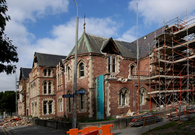
Earthquake damage to the former Christchurch Girls' High building. Bricks have fallen from the gable ends of the building.

A photograph of Colombo Street taken through a car window. In the distance is the earthquake-damaged tower of ChristChurch Cathedral.

This block of shops on Victoria Street was so badly damaged that it had to be demolished following the magnitude 7.1 earthquake that struck Christchurch on Saturday 4 September 2010.

This block of shops on Victoria Street was so badly damaged that it had to be demolished following the magnitude 7.1 earthquake that struck Christchurch on Saturday 4 September 2010.

This block of shops on Victoria Street was so badly damaged that it had to be demolished following the magnitude 7.1 earthquake that struck Christchurch on Saturday 4 September 2010.
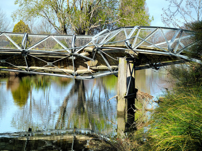
The badly twisted Medway Street footbridge. The photographer comments, "The September 4th 2010 earthquake in Christchurch was so violent that the banks of the Avon River moved towards each other. This footbridge being metal had to twist sideways to release the pressure of being pushed from both river banks. It looked like it had been wrung out like a wet towel".

Damaged rose window of the St John the Baptist Church at Latimer Square; aftermath of the magnitude 7.1 earthquake that struck Christchurch on Saturday 4 September 2010.

Photograph captioned by Fairfax, "Removal of 4 September earthquake-damaged chimney of the 145 year old Canterbury Provincial Council Building".

Photograph captioned by Fairfax, "Removal of 4 September earthquake-damaged chimney of the 145 year old Canterbury Provincial Council Building".

Photograph captioned by Fairfax, "Removal of 4 September earthquake-damaged chimney of the 145 year old Canterbury Provincial Council Building".

Photograph captioned by Fairfax, "Removal of 4 September earthquake-damaged chimney of the 145 year old Canterbury Provincial Council Building".

Photograph captioned by Fairfax, "Removal of 4 September earthquake-damaged chimney of the 145 year old Canterbury Provincial Council Building".

Photograph captioned by Fairfax, "Removal of 4 September earthquake-damaged chimney of the 145 year old Canterbury Provincial Council Building".

Photograph captioned by Fairfax, "Removal of 4 September earthquake-damaged chimney of the 145 year old Canterbury Provincial Council Building".

Damage to TJ's Kazbah in New Brighton. The tower and east end of the building have collapsed onto two parked cars. The photographer comments, "The occupants of the business and rooms all managed to escape alive. A digger was used to make the building safe and then used to sift through the rubble for any surviving belongings. It was a very emotional time for the ex-occupants. The damaged cars were removed before the digger demolished the building".

view to some of the damage in the distance and the building that might be demolished - brick seven storey building - i've always liked this one : ( .

Red stickered door means that this pub on Madras Street is no-go due to structural damage suffered in the magnitude 7.1 earthquake that hit Christchurch on Saturday 4 September 2010.

None

None

Blossom coming out by the Worcester Street bridge.
File reference: CCL-2011-08-12-CanterburyPublic Library pre-demolition-041
From the collection of Christchurch City Libraries.

Our City building extensively propped up.
File reference: CCL-2011-08-12-CanterburyPublic Library pre-demolition-040
From the collection of Christchurch City Libraries.