
The footpath at the foot of the Taylors Mistake Road in Sumner is cordoned off, and a sign reads "Footpath closed. Please wait to be escorted through site".
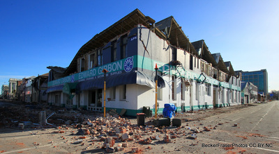
The damaged Edward Gibbon Plumbing Plus building on the corner of Tuam and Madras Streets. The upper storey has partially collapsed, and fallen bricks litter the road below.
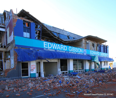
The damaged Edward Gibbon Plumbing Plus building on the corner of Tuam and Madras Streets. The upper storey has partially collapsed, and fallen bricks litter the road below.

The damaged Edward Gibbon Plumbing Plus building on the corner of Tuam and Madras Streets. The upper storey has partially collapsed, and fallen bricks litter the road below.

A photograph of a row of images of faces pasted on a wall. The photograph is captioned by Paul Corliss, "Ferrymead, wall between Tidal View and Ferry Road".

Photograph captioned by BeckerFraserPhotos, "Extensive slumping and cracking near where Horseshoe Lake joins up with the Avon River".
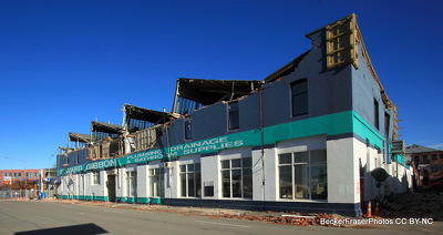
The damaged Edward Gibbon Plumbing Plus building on the corner of Tuam and Madras Streets. The upper storey has partially collapsed, and fallen bricks litter the road below.

The damaged Edward Gibbon Plumbing Plus building on the corner of Tuam and Madras Streets. The upper storey has partially collapsed, and fallen bricks litter the road below.

The damaged Edward Gibbon Plumbing Plus building on the corner of Tuam and Madras Streets. The upper storey has partially collapsed, and fallen bricks litter the road below.

The damaged Edward Gibbon Plumbing Plus building on the corner of Tuam and Madras Streets. The upper storey has partially collapsed, and fallen bricks litter the road below.

A photograph captioned by BeckerFraserPhotos, "Liquefaction covers the car park by the Sumner Cob Cottage".

A photograph of Alasdiar Cassels, Zak Cassels, and Joseph Shanks on the building site for The Tannery.

Photograph captioned by BeckerFraserPhotos, "93 Cambridge Terrace with protective containers and the police headquarters on the right".

Shipping containers protect the road from rockfall in Sumner. On the cliffs above, damaged houses teeter on the edge of the cliff. One of the containers has been decorated with an artwork.

A photograph of a row of images of faces pasted on a wall. The photograph is captioned by Paul Corliss, "Ferrymead, wall between Tidal View and Ferry Road".

A photograph looking east down Gloucester Street, taken at the intersection of Oxford Terrace. The road is closed to vehicles and crowds of people are walking through.

Steel bracing on the Moorhouse Avenue overpass. The photographer comments, "Standing underneath I did hear a clump as if a part of the road overhead was pivoting as a car passed over it".

A powerful aftershock on 13 June has caused a building to partially collapse on the corner of Stanmore Road and Worcester Street. The area has been cordoned off from the public.

Damage to a row of shops on Barbadoes Street. The brick facades have collapsed, crushing the awnings. The building is cordoned off with road cones and police tape.

A "no swimming" sign on the beach at Sumner. In the background are shipping containers protecting the road from rockfall, and above a damaged house teeters on the edge of a cliff.

A photograph of the corner of a badly-damaged building at 128 Manchester Street. Shipping containers are stacked on the road in front of the west-facing facade.

A muddy section at 27 Waygreen Avenue in New Brighton. The section has partly flooded and a road cone has been placed on the section.

The damaged Edward Gibbon Plumbing Plus building on the corner of Tuam and Madras Streets. The upper storey has partially collapsed, and fallen bricks litter the road below.

Damage to buildings down Victoria Street. Members of the public have walked inside the police tape cordon to have a look at the damaged buildings and bricks across the road.

A photograph looking east down Gloucester Street, taken at the intersection of Oxford Terrace. The road is closed to vehicles and crowds of people are walking through.

A powerful aftershock on 13 June has caused a building to partially collapse on the corner of Stanmore Road and Worcester Street. The area has been cordoned off from the public.

A truck on Warden Street in Shirley waits to be loaded with liquefaction silt, which a digger in the background is scraping off the road. The photographer comments, "Liquefaction clean-up".

A photograph of a row of images of faces pasted on a wall. The photograph is captioned by Paul Corliss, "Ferrymead, wall between Tidal View and Ferry Road".

The Mandeville Tavern in Kaiapoi cordoned off with red danger tape. A large crack is visible in the wall of the tavern, and the road and footpath in front are cracked and buckled.

The Mandeville Tavern in Kaiapoi cordoned off with red danger tape. A large crack is visible in the wall of the tavern, and the road and footpath in front are cracked and buckled.