
Vehicles drive through a flooded road in New Brighton. A sign advertising the stronger Christchurch website reads, 'Rebuilding for our future'.

Photograph captioned by Fairfax, "Robert Gerrie, CCC 2 Limited general manager. Spoiled food being dumped at the Parkhouse Road transfer station".

Photograph captioned by Fairfax, "Flooding after high tide on the Avon River post quake. New Brighton Road near the Bower Tavern".

A photograph of a foundation stone from the Christchurch Chinese Methodist Church at 163 Papanui Road. The stone reads, "AD 1894".

A photograph of rubble from demolished buildings on St Asaph Street. An excavator has been parked on the road in front.

Photograph captioned by BeckerFraserPhotos, "New Brighton Road at this point is now below sea level at very high tide!".

View down Hereford Street, looking west from Madras Street. Road work signs and a crane can be seen in the distance.

Photograph captioned by Fairfax, "Major earthquake hits Christchurch. A skateboarder playing in a damaged New Brighton petrol station on Pages Road".

A photograph of street art at Waltham Park. The artwork is on the outside of the public toilets on Waltham Road.

Photograph captioned by Fairfax, "Major earthquake hits Christchurch. A skateboarder playing in a damaged New Brighton petrol station on Pages Road".

Photograph captioned by Fairfax, "Major earthquake hits Christchurch. A skateboarder playing in a damaged New Brighton petrol station on Pages Road".

A photograph of rubble from demolished buildings on St Asaph Street. An excavator has been parked on the road in front.

Photograph captioned by Fairfax, "Major earthquake hits Christchurch. A skateboarder playing in a damaged New Brighton petrol station on Pages Road".

A photograph of a driveway in New Brighton, captioned by BeckerFraserPhotos, "112A, 112B, 112C Bexley Road".

Photograph captioned by Fairfax, "Major earthquake hits Christchurch. A skateboarder playing in a damaged New Brighton petrol station on Pages Road".

A power pole on a lean on the corner of Dallington Terrace and Gayhurst Road. The photographer comments, "Leaning power poles".

Selective colour full size view from one of my previous shots. Edgeware Road, Christchurch. Damaged from the Christchurch Earthquake
Twitter | Facebook |

Photograph captioned by BeckerFraserPhotos, "The Environment Canterbury Emergency Management Office".

Photograph captioned by BeckerFraserPhotos, "The Environment Canterbury Emergency Management Office".

A notice board on the side of the road along Raven Quay in Kaiapoi. The board holds information sheets about earthquake recovery information in Kaiapoi.

A photograph of a sign on the corner of Ilam Road and University Drive at the University of Canterbury. The sign reads, "Emergency, campus closed, no entry".

A photograph of earthquake-damaged buildings along Lichfield Street. Many of the buildings' facades have crumbled, and the bricks have fallen onto the road below.

A photograph of a police car blocking the road outside Christchurch Art Gallery. The Christchurch Art Gallery was used as the emergency operations centre after the September earthquake.

A photograph of major damage to a road in Darfield. UC geology student Dan Hills is standing in the crack to illustrate how deep it is.

A photograph of major damage to a road in Darfield. UC geology student Dan Hills is standing in the crack to illustrate how deep it is.

Police walking down Manchester Street in the aftermath of the 22 February 2011 earthquake. Masonry from several buildings has fallen onto the road.

A graphic giving the status of Central New Brighton School.
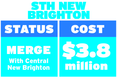
A graphic giving the status of South New Brighton School.

A photograph looking south down Colombo Street from near the Cashel Street intersection. Rubbish skips line the right side of the road.

An aerial photograph of Central New Brighton School in New Brighton.