Search
found 401 results
Canterbury Earthquake September 2010 - Photograph 43
Images, UC QuakeStudies
Residents walk along River Road past large cracks where the road has slumped towards the river. The photographer comments, "Lateral spreading cracks in River Rd; the land left of the crack moved towards the river. The Banks Ave/Dallington Tce end of our block is impassable".
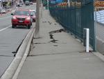
BeckerFraserPhotos September 2010 photograph 059
Images, UC QuakeStudies
Cracks along the road in Avonside Drive. The riverbank has slumped towards the river, separating the land from the road and creating these cracks. Road cones warn drivers of the uneven surface. In the distance, a pile of liquefaction can be seen in front of a house.
We Lived Here: Oxford Terrace Photograph 170
Images, UC QuakeStudies
A photograph of a wire fence that has been placed at the border of 406 Oxford Terrace. 406 Oxford Terrace is the former site of Donna Allfrey's house which was demolished after her land was zoned Red. Behind the fence, gravel has been spread over the ground.
BeckerFraserPhotos November 2011 photograph 278
Images, UC QuakeStudies
Photograph captioned by BeckerFraserPhotos, "Lois Wright at the back door of her home of 45 years, built by her husband. 88 Kingsford Street, Horseshoe Lake. The land is red zoned here and Lois must find another home. At this stage, she doesn't know where".
BeckerFraserPhotos March 2013 photograph 024
Images, UC QuakeStudies
An aerial photograph of Longhurst and Knight's Stream Park, new housing developments in Halswell. Labels have been added to the photograph by BeckerFraserPhotos.
The Gap
Images, UC QuakeStudies
A large crack where the foundation of a building has moved away from the adjoining carpark. The photographer comments, "The gap between Robbies restaurant and bar in New Brighton and the car park after the Christchurch Earthquake".
We Lived Here: Bangor Street Photograph 12
Images, UC QuakeStudies
A photograph of the former site of a house at 58 Bangor Street. The house was demolished after the land was zoned Red. The grass has begun to grow over the site. The house behind has also been demolished, so that Oxford Terrace is now visible in the distance.

20130827_2620_1D3-32 Victoria Square Apartments
Images, eqnz.chch.2010
Awaiting the demolition ball! See the hole punched in by the neighbouring building (now demolished) during the February 22 2011 earthquake. This building is leaning to the north (left) while it's now demolished neighbour was leaning to the south (right). All because the crap land gave way underneath!
We Lived Here: Oxford Terrace Photograph 162
Images, UC QuakeStudies
A photograph of the former site of the Locke family's house at 392 Oxford Terrace. The Locke's house was deconstructed after their land was zoned Red. Wire fencing has been placed around the outside of the neighbouring property. The photographer comments, "The house was deconstructed and rebuilt on another site".
BeckerFraserPhotos October 2010 photograph 048
Images, UC QuakeStudies
The north end of the bridge on Gayhurst Road. During the earthquake, the bridge was forced about 15 centimetres towards the river, the land falling away under the road. Fencing has been placed around the footpath, and the road filled and resealed so that it can still be used by traffic.
We Lived Here: Oxford Terrace Photograph 156
Images, UC QuakeStudies
A photograph of the former site of the Locke family's house at 392 Oxford Terrace. The Locke's house was deconstructed after their land was zoned Red. Wire fencing has been placed around the outside of the neighbouring property. The photographer comments, "The house was deconstructed and rebuilt on another site".

wairoa street red zone
Images, eqnz.chch.2010
one of Christchurch's abandoned suburbs. The land moved - bricks and block walls everywhere collapsed - two multi story buildings folded - 184 people died. Wooden framed houses largely stayed up, many concrete slabs cracked, power poles leaned in liquid ground, surface bubbled, services ruptured .... damage to the cbd still gets the most cover...
Bike Ride in the East Side - Photograph 52
Images, UC QuakeStudies
Liquefaction around QEII stadium. The photographer comments, "A Sunday afternoon ride to New Brighton, then back via Aranui, Wainoni, Dallington, and Richmond. Not a cheerful experience. QE2 stadium. From Frosts Rd, looking along Robin Tait Drive - the stadium looks OK from this distance, though the land has sunk and become waterlogged".
What Happens When You Have a Saggy Bottom
Images, UC QuakeStudies
A fence along the side of the Avon River near the Retour Restaurant has broken and is leaning towards the river. The photographer comments, "After the Christchurch earthquakes the land moved towards the river Avon and in a lot of places buildings and walls sagged down in the direction of the waterway".

Borehole Sediment Samples: Canterbury Museum
Images, Canterbury Museum
Eight white corflute boxes of sediment samples from the borehole drilled adjacent to the Canterbury Museum Rolleston Avenue facade following the 22 February 2011 earthquake. Project number 52160, Bore hole BH02 These sediment samples are from machine drilled borings taken from the land near the Rolleston Avenue facade of Canterbury Museum. The ...
We Lived Here: Bangor Street Photograph 15
Images, UC QuakeStudies
A photograph of the former sites of several houses on Bangor Street. The houses were demolished after the land was zoned Red. A stake has been placed in the ground to the left. A message written on the stake reads, "412 Oxford Terrace waste water". Grass has begun to grow in the empty sites.
A Bit of Dirt Never Hurt!
Images, UC QuakeStudies
A digitally manipulated image of a sign reading "A bit of dirt never hurt". The photographer comments, "This was a sign put up on a section of land in the Port of Lyttelton where an earthquake damaged building had been removed. The cliff at the back had collapsed down probably during the demolition process".
BeckerFraserPhotos November 2011 photograph 279
Images, UC QuakeStudies
Photograph captioned by BeckerFraserPhotos, "Lois Wright on the porch of her home of 45 years, built by her husband, Peter. 88 Kingsford Street, Horseshoe Lake. The land is red zoned here, so all the homes will be demolished and Lois must find another home. At this stage, she doesn't know where".
Digital Photograph: Earthquake Damage to Road on Norwich Quay, Lyttelton
Images, Canterbury Museum
One landscape colour digital photograph taken on 25 February 2011 showing earthquake damage to the road, footpath and retaining wall on Norwich Quay. The photograph is taken from below the intersection of Norwich Quay and Canterbury Street looking east along Norwich Quay. Unlike most areas of Christchurch, land damage on the Port Hills was due ...
BeckerFraserPhotos November 2011 photograph 303
Images, UC QuakeStudies
Photograph captioned by BeckerFraserPhotos, "This loop of the Avon encircles Horseshoe Lake and gives the area its name and its attraction as a place to live. The land close to the Avon River has severe issues with slumping, lateral movement and liquefaction, so that much of it is red zoned and the houses will be demolished".
WEMO ERT Team Set 3 - April 2011 - Photograph 10
Images, UC QuakeStudies
A photograph of an ICOM IDAS Repeater next to the information for the Civil Defence Response Team networks. The IDAS is a digital land mobile radio system which retransmits radio signals. It was used by the Civil Defence to extend the range of their digital radios during the emergency response to the 22 February 2011 earthquake.
BeckerFraserPhotos December 2011 photograph 0400
Images, UC QuakeStudies
An aerial photograph of a residential area in Burwood. The photograph has been captioned by BeckerFraserPhotos, "Anzac Drive Bridge over the River Avon at the top of the photograph. Hulverstone Drive and New Brighton Road are prominent in this photograph. The land beside the river is red-zoned with a green-zoned strip alongside Anzac Drive".

20111230_7222_1D3-70 New Brighton
Images, eqnz.chch.2010
20111230_7222_1D3-70 New Brighton Further damage to the bank following the two quakes on 23/12/11. The sewer line broke here and was repaired (patched) by council staff on Christmas Eve. It is hard to beleve that this rock wall was level with the land here, before any of the quakes. #2004
Bringing Music to the Masses
Images, UC QuakeStudies
A digitally manipulated photograph of a stencilled logo for the Christchurch School of Music. The photographer comments, "The Christchurch School of Music donated several old broken pianos to be placed on Gap Filler sites in Christchurch. Gap Filler make the land where buildings have been demolished into places the local inhabitants can enjoy. As in Maths two negatives make a positive".
BeckerFraserPhotos November 2011 photograph 302
Images, UC QuakeStudies
Photograph captioned by BeckerFraserPhotos, "Horseshoe Lake area of Burwood has that name because a loop of the Avon River encircled it in a horseshoe shape. There used to be an attractive walk alongside the loop of the River. Much of the path is now under water as the land level has subsided as a result of the earthquakes".
BeckerFraserPhotos December 2011 photograph 0364
Images, UC QuakeStudies
An aerial photograph of the Horseshoe Lake district. The photograph has been captioned by BeckerFraserPhotos, "The area circumscribed by a loop of the River Avon is all zoned red, except for the park at the upper left. On the other side of the river, most of the land is also red-zoned apart from the piece in the upper left".
We Lived Here: Oxford Terrace Photograph 142
Images, UC QuakeStudies
A photograph of the former site of a block of apartments at 440 Oxford Terrace. The apartments were demolished after the land was zoned Red. Grass has begun to grow over the site. The number 466 has been spray-painted on the footpath in front, as well as the numbers of each apartment. This number is the incorrect street number for the site.

Digital Photograph: Site of the Harbourlight Theatre, London Street, Lytte…
Images, Canterbury Museum
One landscape colour digital photograph taken on 14 September 2012 showing the site of the Harbourlight Theatre on London Street. The retaining wall at the rear of the site collapsed and part of the adjoining land eroded. Also visible in the photograph are the side walls of the Bank of New Zealand and the former Westpac Branch, now Himalaya Desi...

Avonside - this pumping station used to be level. This whole corner of the…
Images, eqnz.chch.2010
The result of the magnitude 7.1 Christchurch earthquake at 4.35am on September 4th 2010. Taken from Dallington Terrace looking towards Avonside Drive. This pumping station used to be level. When the tide is in that flax bush on the bend appears to be growing from the middle of the river, suggesting the land has slumped about a meter.

20130901_2869_1D3-150 Wilson City!
Images, eqnz.chch.2010
As buildings are demolished as a result of the earthquake in 2011, Wilson Carparking are waiting to pounce on each bit of vacant land. Someone suggested about a year ago that the city be renamed "Wilson" as that name appears more in the central city than Christchurch does! In the background the CERES NZ nibbler attacks the support structure fo...