
On the previously unknown faultline on Highfield Road in mid-Canterbury! This was where two tectonic plates slipped, causing the magnitude 7.1 earthquake on Saturday 4 September 2010.

The faultline cuts across Telegraph Road, leaving a kink in its originally straight alignment; aftermath of the magnitude 7.1 earthquake in mid-Canterbury on Saturday 4 September 2010.

Slipping of the tectonic plates caused tension cracks on this previously unknown faultline that runs through this paddock; magnitude 7.1 earthquake in mid-Canterbury on Saturday 4 September 2010.

Slipping of the tectonic plates caused tension cracks on this previously unknown faultline that runs through this paddock; magnitude 7.1 earthquake in mid-Canterbury on Saturday 4 September 2010.

This originally straight farm fence has been laterally displaced at least 2 metres where it crosses the previously unknown faultline from which the Saturday 4 September 2010 earthquake originated.

This originally straight farm fence has been laterally displaced at least 2 metres where it crosses the previously unknown faultline from which the Saturday 4 September 2010 earthquake originated.

Looking along this previously unknown faultline that runs through this paddock, note how the ground had heaved and subsided; magnitude 7.1 earthquake in mid-Canterbury on Saturday 4 September 2010.

The faultline cuts across Telegraph Road, leaving a kink in its originally straight alignment; aftermath of the magnitude 7.1 earthquake in mid-Canterbury on Saturday 4 September 2010.

Damage to the St John The Evangelist Catholic Church in Leeston suffered during the magnitude 7.1 earthquake that struck mid-Canterbury on Saturday 4 September 2010.

Hehehe ..... did the surveyors get the road setout wrong?
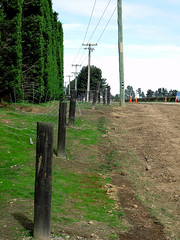
This previously straight road is now kinked across this previously unknown faultline along which the Saturday 4 September 2010 magnitude 7.1 earthquake originated.

Hehehe ..... did the surveyors get the road setout wrong?
This previously straight road is now kinked across this previously unknown faultline along which the Saturday 4 September 2010 magnitude 7.1 earthquake originated.

The farmers in this area swore that this road was straight when they were returning from the pub on Friday 3 September 2010, the night before the magnitude 7.1 earthquake struck.

The farmers in this area swore that this road was straight when they were returning from the pub on Friday 3 September 2010, the night before the magnitude 7.1 earthquake struck.

Taken as the severity of the situation began to sink in to most of the people wandering around. Police, Fire and other emergency personal showed a fantastic response to how they dealt with the situation they had.
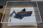
One oblong perspex covered 3-D model of the fault plains associated with the 4 September 2010 Darfield earthquake; top of the model also acts as a map overlay. Geologists continue to study the 4 September 2010 earthquake and consider it is likely to have been a complex event with several faults rupturing simultaneously. This model provides one ...

The St John The Evangelist Catholic Church in Leeston was cordoned off due to damage suffered during the magnitude 7.1 earthquake that struck mid-Canterbury on Saturday 4 September 2010.

The St John The Evangelist Catholic Church in Leeston was cordoned off due to damage suffered during the magnitude 7.1 earthquake that struck mid-Canterbury on Saturday 4 September 2010.
The farmer swore that his fence was erected in a straingt line, but mother nature had other ideas!
Aftermath of the Saturday 4 September 2010 magnitude 7.1 earthquake at the previously unknown faultline along which the quake originated.

The farmer swore that his hedge was planted in a straingt line, but mother nature had other ideas!
Aftermath of the Saturday 4 September 2010 magnitude 7.1 earthquake at the previously unknown faultline along which the quake originated.

The magnitude 7.1 earthquake that struck mid-Canterbury on Saturday 4 September 2010 broke the tip of the spire of the St John The Evangelist Catholic Church in Leeston

The September Canterbury earthquake. These pictures were taken of The New Zealand Army, along with Police, minding the cordons. This was beside The Press building, and behind the Christchurch Cathedral.
Note: these photos were taken on a cellphone; mind the quality.

The September Canterbury earthquake. These pictures were taken of Colombo Street in Sydenham. A lot of masonry in this area has been damaged/fallen down.
A second hand dealer store. This is next to Penny Lane which had to relocate down the street.
Note: these photos were taken on a cellphone; mind the quality.

The farmer swore that his fence was erected in a straingt line, but mother nature had other ideas!
Aftermath of the Saturday 4 September 2010 magnitude 7.1 earthquake at the previously unknown faultline along which the quake originated.

The September Canterbury earthquake. These pictures were taken of Colombo Street in Sydenham. A lot of masonry in this area has been damaged/fallen down.
Ascot TV. This has relocated further south on Colombo Street. Apparently their building on Cranford Street was also severely damaged.
Note: these photos were taken on a cellphone; mind the qu...

One multi-coloured soft-cover book entitled 'Quake: the Big Canterbury Earthquake of 2010' with colour photographs by David Wethey and text by Ian Stuart. ‘Quake: The Big Canterbury Earthquake of 2010’ contains aerial photographs of the damage to many major heritage sites in Canterbury between Kaiapoi and Darfield after the 4 September 2010 ear...

The farmer swore that his fence and hedge were in a straingt line, but mother nature had other ideas!
Aftermath of the Saturday 4 September 2010 magnitude 7.1 earthquake at the previously unknown faultline along which the quake originated.

The ground slipped laterally at this previously unknown faultline across Highfield Road in mid-Canterbury, resulting in a relative displacement of at least 2 metres and the magnitude 7.1 earthquake on Saturday 4 September 2010. Note the now misaligned fence posts, hedge and road.

The September Canterbury earthquake. These pictures were taken of Colombo Street in Sydenham. A lot of masonry in this area has been damaged/fallen down.
Angus Donaldson copy service. This has moved down the road on Colombo Street. It is now sharing the premises with Penny Lane Records.
Note: these photos were taken on a cellphone; mind the qu...

Photograph captioned by Fairfax, "Damage to St. Mary's Anglican Church Timaru resulting from 7.1 Magnitude Earthquake centred near Darfield. (L to R on ground): Archdeacon Andrew Starky; Vicar Indrea Alexander and Concillor Ray Bennett watch as Craig Perkins and Kevin Deam are hoisted by crane to remove damaged spires from the church tower. (L to R): Builder Kevin Deam and St. Mary's parishioner Craig Perkins inspect a damaged spire on the church tower".

Two huge wrestlers, one representing 'Port Hills fault' and the other 'Greendale fault' struggle together over a broken Christchurch. Another wrestler, representing 'Other faults' appears in the distance yelling 'Is it my turn yet?' Context - Christchurch has now had three major earthquakes and thousands of aftershocks. It now appears likely that the Christchurch quakes resulted from activity on a fault extending directly eastward from the Alpine fault that remained unknown until last year, says Roger Musson, a seismologist at the British Geological Survey in Edinburgh. The new fault first came to light last September (4th) when a stronger but less calamitous quake shook Darfield, 40 kilometres west of Christchurch. Musson says the latest quake (Feb 22, 2011) probably resulted from an eastward continuation of activity on the same fault. "It has probably not moved for tens of thousands of years, so lots of strain built up," says Musson. The third major quake happened on 13th June 2011. (New Scientist - February 22, 2011)
Quantity: 1 digital cartoon(s).