
Eight white corflute boxes of sediment samples from the borehole drilled adjacent to the Canterbury Museum Rolleston Avenue facade following the 22 February 2011 earthquake. Project number 52160, Bore hole BH02 These sediment samples are from machine drilled borings taken from the land near the Rolleston Avenue facade of Canterbury Museum. The ...
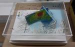
One oblong perspex covered 3-D model of the fault plains that ruptured to cause the 22 February and 13 June 2011 earthquakes; top of the model also acts as a map overlay. This model provides a visual demonstration of the geological forces that caused the 22 February and 13 June 2011 earthquakes. These forces were so strong that parts of the Por...
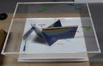
One oblong perspex covered 3-D model of the fault plains associated with the 4 September 2010 Darfield earthquake; top of the model also acts as a map overlay. Geologists continue to study the 4 September 2010 earthquake and consider it is likely to have been a complex event with several faults rupturing simultaneously. This model provides one ...

The magnitude 7.1 Christchurch earthquake broke off an enormous chunk of Castle Rock in the Port Hills which has tumbled down towards the Lyttelton tunnel.
View from Morgan's Valley (-43.578037° 172.714828°).

Under the caption, young people carrying their baggage flutter into the air, away from Canterbury and toward 'Oz'.
In September GNS Earth Sciences reported that after the earthquakes, the Greendale and associated faults were still moving as they settled into a new configuration. At the same time the young were leaving Canterbury (and New Zealand) for a better future in Australia. The population of New Zealand was moving into a new configuration.
Quantity: 1 digital cartoon(s).

None

None

None

None

None

None

None
None

None

None
None

None
None

None

Rolleston/Burnham, South Island, NZ
It's been a busy few weeks! Was away on geology fieldtrips all the previous two weeks, then on Saturday morning 4th September 2010 at 4.35 am we got woken in Westport to a reasonable but very long earthquake. My husband was back in Christchurch at the time and texted me saying "are you ok?". I replied, "yes!"...
None

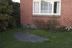
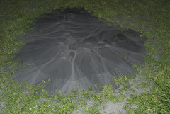
This one was really flowing out of the ground.

None

These were scattered across the park.

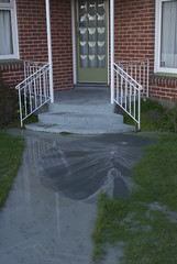
Robbie watches a sand volcano smother his driveway.

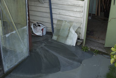
Sand volcanoes put the silt all over the road.

The earthquake knocked over the bird bath.

Debra points at the beginnings of a sand volcano not long after the big earthquake.

An usual thing to see coming from the ground in Hoon Hay, Christchurch.

Two huge wrestlers, one representing 'Port Hills fault' and the other 'Greendale fault' struggle together over a broken Christchurch. Another wrestler, representing 'Other faults' appears in the distance yelling 'Is it my turn yet?' Context - Christchurch has now had three major earthquakes and thousands of aftershocks. It now appears likely that the Christchurch quakes resulted from activity on a fault extending directly eastward from the Alpine fault that remained unknown until last year, says Roger Musson, a seismologist at the British Geological Survey in Edinburgh. The new fault first came to light last September (4th) when a stronger but less calamitous quake shook Darfield, 40 kilometres west of Christchurch. Musson says the latest quake (Feb 22, 2011) probably resulted from an eastward continuation of activity on the same fault. "It has probably not moved for tens of thousands of years, so lots of strain built up," says Musson. The third major quake happened on 13th June 2011. (New Scientist - February 22, 2011)
Quantity: 1 digital cartoon(s).