
Search
found 58159 results
Digital Photograph: Demolition of the former Library, Council Chambers and…
Images, Canterbury Museum
One landscape colour digital photograph taken on 11 June 2011 showing the demolition of the old Lyttelton Library, Council Chambers and Magistrates' Court on the corner of Oxford Street and Sumner Road. The photograph shows the upper floor of the building being demolished with a high reach digger and a jet of water being played on the building ...

Digital Photograph: Demolition of Former Canterbury Hotel, corner of Norwi…
Images, Canterbury Museum
One landscape colour digital photograph taken on 14 July 2011 showing the demolition of the former Canterbury Hotel on the corner of Norwich Quay and Oxford Street. At the time of demolition the ground floor was occupied by the Magma Gallery. Also visible in the photograph are 'Tin Palace' and a former office building which shows repairs made by...

Digital Photograph: Earthquake Damage to Canterbury Hotel and shops. Oxfor…
Images, Canterbury Museum
One landscape colour digital photograph taken on 15 June 2011 showing earthquake damage to the former Canterbury Hotel and adjoining row of shops on Oxford Street. This photograph was taken on Oxford Street and shows the collapsed façade of the row of shops behind safety fencing, the interior of the building is exposed. Shadbolt House is visib...

Digital Photograph: Former Convent of Our Lady of Mercy, Exeter Street, an…
Images, Canterbury Museum
One landscape colour digital photograph taken on 30 June 2011 showing earthquake damage to the former Convent of Our Lady of Mercy and to the Catholic Church of St Joseph the Worker. Photograph taken from St. Davids Street The sense of loss felt when confronted with the collapse or demolition of an historic building is compounded when that bui...

Digital Photograph: Temporary Premises of Lyttelton Bakery, corner of Norw…
Images, Canterbury Museum
One landscape colour digital photograph taken on 16 June 2011 showing the Lyttelton Bakery operating from a portable building on the Corner of Canterbury Street and Norwich Quay. This portable building has been placed on the site of the Royal Hotel. Also visible in the photograph are Shadbolt House and the rear of the buildings on the south side...

Digital Photograph: Temporary Theatre, London Street, Lyttelton
Images, Canterbury Museum
One landscape colour digital photograph taken on 6 September 2011 showing the temporary theatre erected on the site of the Volcano Café on London Street for a production of Macbeth by The Loons Circus Theatre Company. The green canopy supported on shipping containers was used to shelter the audience. The stage area was the demolition site partia...

Digital Photograph: Earthquake damage to the Lyttelton Timeball Station.
Images, Canterbury Museum
One landscape colour digital photograph taken on 16 June 2011 showing the site of the Timeball Station after its collapse. Part of the ground floor remains visible. Photograph taken from Oxford Street Overbridge. Architect The 13 June 2011 earthquakes caused the collapse of the already damaged Lyttelton Timeball Station. After the 22 February ...

Digital Photograph: Partial Demolition of the Old Lyttelton Harbour Board …
Images, Canterbury Museum
One landscape colour digital photograph taken on 16 June 2011 showing the partial demolition of the old Lyttelton Harbour Board Offices on the corner of Oxford Street and Norwich Quay. The photograph shows the temporary roof being constructed over the original ground floor of the building. At the time of the 22 February 2011 earthquake the build...

Digital Photograph: Earthquake damage to Church of the Most Holy Trinity, …
Images, Canterbury Museum
One landscape colour digital photograph taken on 15 June 2011 showing earthquake damage to the Anglican Church of The Most Holy Trinity in Winchester Street, Lyttelton. Photograph shows collapsed roof of the nave and north transept. Photograph taken from the north side of the church. Architect The collapse of the Church of the Most Holy Trinity ...
Digital Photograph: Earthquake Damage to Lyttelton Roman Catholic and Diss…
Images, Canterbury Museum
One landscape colour digital photograph taken on 30 June 2011 showing earthquake damage to graves in Lyttelton Roman Catholic and Dissenters (Public) Cemeteries in Reserve Terrace. Most of the headstones and grave surrounds in the photograph show damage. Looking east in the Dissenters (Public) section of the cemetery. The Lyttelton cemeteries a...

Digital Photograph: Earthquake damage to St John's Church, Winchester Stre…
Images, Canterbury Museum
One landscape colour digital photograph taken on 15 June 2011 showing earthquake damage to the Presbyterian Church of St John in Winchester Street, Lyttelton. Photograph shows the collapsed roof and tower. The photograph is taken from the southern side of the church. Architect The destructive force of the 14 June 2011 earthquakes on buildings in...

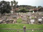
Digital Photograph: Earthquake Damage to Lyttelton Roman Catholic and Diss…
Images, Canterbury Museum
One landscape colour digital photograph taken on 30 June 2011 showing signs warning of the danger posed by unstable headstones in Lyttelton Roman Catholic and Dissenters (Public) Cemeteries in Reserve Terrace. Several toppled headstones and collapsed grave surrounds are visible in the photograph. Looking east from the main gate. The Lyttelton c...

Digital Photograph: Earthquake damage to a retaining wall, Lyttelton
Images, Canterbury Museum
One landscape colour digital photograph taken on 30 June 2011 showing earthquake damage to a section of retaining wall in Sumner Road. Plastic sheeting installed to stabilise previous damage and protect from water erosion is visible to the right of the photograph. Also visible in the photograph is a boarded up broken window and temporary safety ...

Digital Photograph: Earthquake damage to Church of the Most Holy Trinity, …
Images, Canterbury Museum
One landscape colour digital photograph taken on 15 June 2011 showing earthquake damage to the Anglican Church of The Most Holy Trinity in Winchester Street, Lyttelton. Photograph shows collapsed roof of the nave and north transept. Photograph taken from the northwest corner of the church. Architect The collapse of the Church of the Most Holy Tr...

Digital Photograph: Earthquake Damage to Canterbury Hotel and shops. Oxfor…
Images, Canterbury Museum
One landscape colour digital photograph taken on 15 June 2011 showing earthquake damage to the former Canterbury Hotel and adjoining row of shops on Oxford Street. This photograph was taken on Oxford Street and shows the collapsed façade of the row of shops behind safety fencing, the interior of the building is exposed. The design of many older...

Digital Photograph: Demolition of former Library and Fire Station, corner …
Images, Canterbury Museum
One landscape colour digital photograph taken on 6 September 2011 showing the demolition of 2 Sumner Road, the former library and fire station. This building was a private residence at the time of its demolition. Photograph taken looking north on Oxford Street. Also visible in the photograph are the Lyttelton Information Centre, an entrance to ...

Digital Photograph: Earthquake damage to St John's Church, Winchester Stre…
Images, Canterbury Museum
One landscape colour digital photograph taken on 15 June 2011 showing earthquake damage to the Presbyterian Church of St John in Winchester Street, Lyttelton. Photograph shows the collapsed roof and tower. The photograph is taken from the southeast corner of the church. Architect St John's Lyttelton was one of the oldest Presbyterian Churches in...
Christchurch Press Infographic: 30 June 2012 (1)
Images, UC QuakeStudies
A graphic from an article about CTV victim Tamara Cvetanova.

Model: Temple for Christchurch
Images, Canterbury Museum
One model of the Temple for Christchurch with a rectangular base of Jarrah and solid silver conical shapes and wave like walls representing the movement of the 22 February 2011 earthquake. Based on the Temple for Christchurch sculpture that was designed by Hippathy Valentine.
Photograph by Kaspar Middendorf 324
Images, UC QuakeStudies
A tribute left on the cordon fence around the CTV Building site. The card shows a photograph of rescuers working on the CTV site, and reads, "Some of the guys who found you!! Thank you!".
US Embassy Photograph 63
Images, UC QuakeStudies
Members of the New Zealand Police lifting a dog in a harness through the window of a damaged building.
Christchurch Press Infographic: 1 November 2012 (5)
Images, UC QuakeStudies
A logo for a feature titled, "CTV inquest".
Christchurch Press Image: Iain McGregor, 2011:02:22 13:39:35
Images, UC QuakeStudies
Photograph captioned by Fairfax, "Earthquake damage in central Christchurch after a 6.3 earthquake. A businessman walks down the street with two computers in the minutes after Tuesday's quake".
Creator unknown: Christ Church Cathedral, Christchurch, with spire being r…
Images, Alexander Turnbull Library
Christ Church Cathedral, Christchurch, with spire being rebuilt after the 1901 earthquake. Photographer unidentified. The nave, tower and spire of Christchurch Cathedral was completed in 1881. Work on completeing the rest of the building began in 1900. In 1902 the transcepts were finished and work started on the chancel and apse. An earthquake in 1901 cracked the upper part of the spire in two places. In this photograph which dates from late 1902/1903 (see scaffolding beyond the transcept indicating work on chancel) the upper part of the spire has been removed by Messrs Graham and Greig in preparation for replacing this section with a copper covered wooden structure. The Cathedral was completed in 1904. (Information from "Vision and Reality; Christchurch Cathedral in the Square," Colin Brown, Christchurch, 2000 and "A Dream of Spires," Ian Lochhead, Canterbury University Press, 1999, page 153.) Preparation for erecting the scaffolding was reported in the Christchurch Star 15 January 1902. The cross was replaced on the top of the new copper covered wooden section of the spire on 29 June 1903. Source of descriptive information - Notes on file print. Source of title - Title supplied by Library Quantity: 1 b&w original negative(s). Physical Description: Glass negative
Earthquake damage to the road from Cheviot to Port Robinson
Images, Alexander Turnbull Library
Earthquake damage to the road from Cheviot to Port Robinson, 1901. Taken by an unidentified photographer. This is a copy of a photograph from `The Weekly Press', Nov 27, 1901 Note on back of file print reads: "Fissures on the road from Cheviot to Port Robinson. There is a creek on the right side of the road, and below the fissure the road has fallen towards it.....and is 2 1/2' below its proper level. The fissures are 2 1/2' deep" (Probably the caption from `The Weekly Press') Quantity: 1 b&w original negative(s).
Nisbet, Alistair, 1958- :"Maybe NOW they'll let me into the Red Zone!" ...…
Images, Alexander Turnbull Library
Cartoon depicts a person wearing a "Rachel Hunter disguise" saying "Maybe NOW they'll let me into the Red Zone!". A second person responds "It won't happen overnight... but it will happen!". Refers to frustration from Christchurch business owners at not being allowed into the Red Zone following the earthquake on 22 February 2011. Source of information: Heather, Ben. "Anger rising outside red zone". 'The Press', 3 June 2011, https://www.stuff.co.nz/the-press/news/christchurch-earthquake-2011/5094323/Anger-rising-outside-red-zone accessed 25 November 2025. Title taken from item. Quantity: 1 digital cartoon(s). Processing information: Description written by Library staff updated as part of reparative description work November 2025. Details available on request.
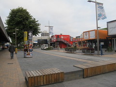
Re:START
Images, eqnz.chch.2010
Friday 22 February 2013. File reference: CCL-2013 -02-22- IMG_4088 From the collection of Christchurch City Libraries.

St Asaph Street
Images, eqnz.chch.2010
Friday 22 February 2013. File reference: CCL-2013 -02-22-IMG_4082 From the collection of Christchurch City Libraries.

Growth on Cashel Street
Images, eqnz.chch.2010
Friday 22 February 2013. File reference: CCL-2013 -02-22-IMG_4046 From the collection of Christchurch City Libraries.

Manchester Street
Images, eqnz.chch.2010
Friday 22 February 2013. File reference: CCL-2013 -02-22-IMG_3965 From the collection of Christchurch City Libraries.