
With the land dropping about 1metre to 1.4metres after the earthquakes, a few roads besides the Avon and Heathcote Rivers are flooded with very high tides. Extra stop banks (on right) erected after the quakes have helped, but the road is now well below high water level.
New Brighton Road, just short of New Brighton. The Pages Road bridge may b...

Palmers Road, New Brighton

Corner Cresswell Ave, New Brighton Road

20130808_2296_1D3-40 New Brighton bridge
Prior to the earthquakes the stone wall at right was near road level. Now it is about 1.5m (4-5ft) lower.
#4075

None

Water supply building, Palmers Road, New Brighton

The old New Brighton Power Boat Club building was badly damaged in the February 2011 earthquake, and is only now (July 2012) being demolished.
The building is just down the road from where I grew up and is a New Brighton iconic building.

The old New Brighton Power Boat Club building was badly damaged in the February 2011 earthquake, and is only now (July 2012) being demolished.
The building is just down the road from where I grew up and is a New Brighton iconic building.

Palmers Road, near the corner of Caithness Street, New Brighton, Christchurch.

None

20100918_3507_1D3-47 Pumping Station - Christchurch earthquake
The pumping station at the corner of New Brighton Road and Palmers Road. New Brighon Road is still closed (2 weeks after quake) at this point.
#403

Aftermath of September 4th Earthquake in Canterbury NZ. Bridge Street, South Brighton, Christchurch.

Aftermath of September 4th Earthquake in Canterbury NZ. Bridge Street, South Brighton, Christchurch.
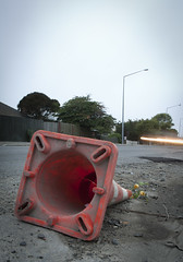
A month after the 1st anniversary of the deadly Christchurch earthquake (22/02/11) a road cone lies on New Brighton Road, alongside the Avon River.
Part of the earthquake 1st anniversary remembrance was for people to place flowers in road cones (and there are hundreds of thousands in the city). Many had flowers in them, as this one did.
Photo ...

20130817_2457_1D3-400 The story of Christchurch (Day 229/365)
Many roads are closed all over eastern Christchurch as infra-structure repairs are carried out, whether it be water supplies, sewer repairs (as is the case here) or general road repairs, In just over two weeks it will be three years since the first earthquake happened (4th September...
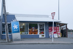
20120321_2397_1D3-47 Beachcomber Dairy
Corner of New Brighton Road and Rawson Street, New Brighton. This diary is inside the suburban red zone and will probably be demolished some time in the future. See how the earthquakes have moved the footpath - the post and phone box used to stand straight! This is one of the Teleccom Wi-Fi hotspot boo...

None

None

20160415_0029_1D3-24 Red Zone Closures
The permanent closure (to motor vehicles) of the Bexley red zone streets has started.
This was once the main south-north route just west of the Avon River in the New Brighton area, till an expressway (ring road) was built about 80m to the west (right) about 12-13 years ago. Then it became just another ...

There are occasional sewerage spills into the Avon River while all the sewer and road repairs are carried out. This rock wall was level and well above high tide level prior to the eathquakes. All the houses that can been seen here (except for those on the distant Port Hills) are in the suburban "red zone" and are still to be demolished.