
A photograph of the former site of the house at 466 Oxford Terrace, taken from the site next door. The house was demolished after the land was zoned Red. Wire fencing has been placed around the site as a cordon.

A photograph of 386 and 378 Oxford Terrace, taken from across the road. The former site of Doug Sexton's house is on the right, behind the wire fence. Sexton's house was demolished after his land was Red zoned.

The PricewaterhouseCoopers demolition site on Armagh Street viewed through a barbed wire fence. Water has filled the basement area.

Vehicles drive through a flooded road in New Brighton. A sign advertising the stronger Christchurch website reads, 'Rebuilding for our future'.

Vehicles drive through flooded roads in New Brighton.

Scaffolding surrounds the Bridge of Remembrance on Cashel Street.

The damaged Bridge of Remembrance on Cashel Street. The bridge is surrounded by scaffolding. A security fence placed around the site to restrict access.

Damage to the north side of ChristChurch Cathedral. The damaged windows have been boarded up and weeds can be seen growing in the lawn. A walkway from Gloucester Street to the Square was opened up for a few days to allow the public a closer look at the cathedral.

The damaged Bridge of Remembrance on Cashel Street. The bridge is surrounded by scaffolding. A security fence placed around the site to restrict access.

Vehicles drive through flooded roads in New Brighton.

A photograph of the former site of a house at 466 Oxford Terrace. The house was demolished after the land was zoned Red. Grass has begun to grow on the site. The house number has been spray-painted on the footpath in front.

An aerial photograph of Irene Street in Horseshow Lake, Dallington.

A photograph of the former site of a block of apartments at 440 Oxford Terrace. The apartments were demolished after the land was zoned Red. Grass has begun to grow over the site. The number 466 has been spray-painted on the footpath in front, as well as the numbers of each apartment. This number is the incorrect street number for the site.

An aerial photograph of the Horseshoe Lake area, with Queensbury Street in the centre.
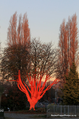
Artist Peter Majendie's decorated tree on the corner of Manchester Street and Cambridge Terrace. The tree has been covered with a large frost cloth and hi-vis material for the launch of an earthquake fund by the Canterbury Community Trust.

An aerial photograph of a residential area in Kaiapoi.

A view from Cambridge Terrace of the damaged Our City O-Tautahi building, formerly the Municipal Chambers. Scaffolding and steel bracing has been placed along the front of the building.

A photograph captioned by BeckerFraserPhotos, "Demolition of the BNZ building in Armagh Street".

The partially-demolished BNZ building in Cathedral Square.

An aerial photograph of Kairaki over the Waimakariri River.

A photograph captioned by BeckerFraserPhotos, "Bonnington's on Manchester Street".

An aerial photograph looking north over Avonside. In the bottom centre of the photograph, Avonside Girls High School can be seen.

Scaffolding surrounds the Cathedral Junction building on Worcester Street. Security fences have been placed around the building to restrict access.

A demolition site on the corner of Manchester and Cashel Street. A truck is parked next to a pile of rubble behind a security fence. The damaged awnings of the stores to the left can be seen in the background.

A photograph of the former site of Siobhan Murphy's house at 436 Oxford Terrace. Murphy's house was demolished after her land was zoned Red. Grass has grown over the site.

An aerial photograph looking across Burwood to the Travis Wetlands and Bottle Lake Reserve.

Multiple cranes viewed through a cordon fence. The Novotel Hotel building stands in the foreground and the Rendezvous Hotel building in background.

The eastern face of Christ Church Cathedral. The damaged windows have been boarded up. A shipping container sits in the overgrown garden.

A member of the New Zealand Army stands outside a cordon check point on Hereford Street.

An aerial photograph of Horseshoe Lake, a residential area in Burwood.