
An infographic illustrating an accountability scorecard given to the Christchurch City Council.

A map showing the proposed location of the central city retail precinct.

A graphic illustrating statistics on food parcels distributed by the City Mission.

An infographic showing estimated repair costs for major Christchurch City Council facilities.

A graphic comparing healthy behaviours in Christchurch and other New Zealand cities.

A infographic giving the status of large buildings in the central city.
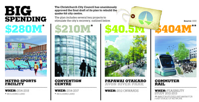
An infographic showing key projects in the Christchurch City Council's recovery plan.

Two people survey fallen bricks from a building in the city centre.

The Christchurch Art Gallery, with the City Gallery Apartments in the background.

Photograph captioned by Fairfax, "Earthquake in Christchurch. Damage around the city boundary".

Roof of a church protected with a tarpaulin in the central city.

Photograph captioned by Fairfax, "Earthquake in Christchurch. Damage around the city boundary".

Photograph captioned by Fairfax, "Earthquake in Christchurch. Damage around the city boundary".

Taped and boarded up windows on a building in the city centre.

Damage to the roof of the Redpath's Building in the city centre.

A map showing the locations of proposed developments in the central city.
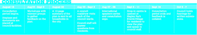
A timeline for the consultation process for the draft Central City Plan.

A city apartment complex and the Christchurch Casino inside the cordon fence.

A chart giving costs for repair or rebuild of Christchurch City Council facilities.
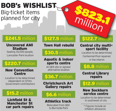
A graphic listing major facilities planned to be built by Christchurch City Council.

A table showing the results of Christchurch City Council's Detailed Engineering Evaluation assessments.

A map showing areas of the central city where brothels will be allowed.

A page banner promoting an article about damage to the City Council offices.
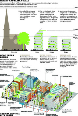
An infographic illustrating building height limits outlined in the draft Central City Plan.
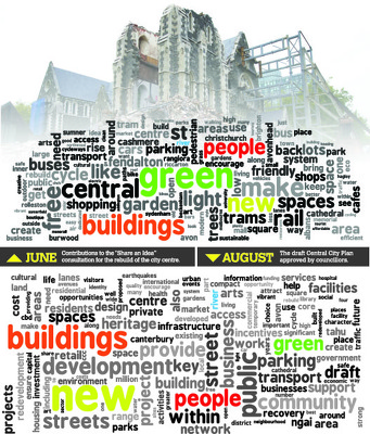
Word clouds comparing the draft Central City Plan to Share an Idea contributions.

A photograph of the partially-demolished City Council Civic Offices on Manchester Street.

A photograph of the partially-demolished City Council Civic Offices on Manchester Street.

Painting on the wall of a broken building visible in the central city.

The Crossing building on City Mall seen from the walkway to Cathedral Square.

An infographic showing retail floor size limits in the draft Central City Plan.