
A photograph of a colourful crocheted cover for a shipping container. It has various patterns including a heart and a group of red flowers.

People looking into the Red Zone through viewing windows at the east end of Re:Start. Flowers has been threaded through the cordon fence.

An aerial photograph captioned by BeckerFraserPhotos, "East Kaiapoi. Much of the area on the left of the picture is residential red zone".

Photograph captioned by BeckerFraserPhotos, "Colour matched sewerage pump, building and portaloo in Wainoni Road".

Photograph captioned by BeckerFraserPhotos, "Sam Crofskey of C1 Coffee standing in the ground floor space of the Alice in Videoland that he is fitting out for his coffee roastery and cafe".

An aerial photograph captioned by BeckerFraserPhotos, "Kerrs Reach, with Porritt Park in the centre".

A photograph of a road cone decorated with Christmas tinsel. The photograph is captioned by BeckerFraserPhotos, "Kingsford Street, Horseshoe Lake, Burwood".
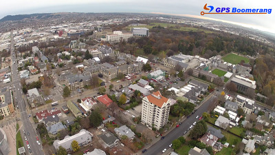
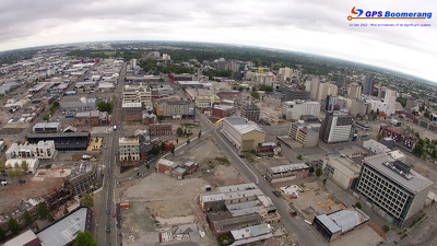
A snapshot from GPS Boomerang's SmartBird flight over the Christchurch red zone on 5 June 2012, looking over the Arts Centre with Christ's College to the right.

A laminated sign for the 2011 Festival of Flowers attached to a wooden planter. The plants in the planter are dry and dead. The photographer comments, "The theme for the 2011 Festival of Flowers was 'burst! of water'. The Christchurch February earthquake came and water and sand called liquefaction burst out of the ground all around the area. Ironically the plants for the festival were left unattended in the cordoned off red zone and they would have loved a little burst of water".

A photograph of a sign on a house reading, "Red zone, yeah right". The photograph is captioned by BeckerFraserPhotos, "Featherston Avenue, Pines Beach".

A snapshot from GPS Boomerang's SmartBird flight over the Christchurch red zone on 5 June 2012, looking over Manchester Street with the Holiday Inn in the background.
A snapshot from GPS Boomerang's SmartBird flight over the Christchurch red zone on 5 June 2012, looking over Manchester Street with the Holiday Inn in the background.

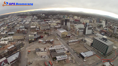
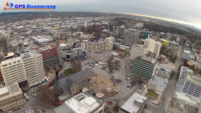
A snapshot from GPS Boomerang's SmartBird flight over the Christchurch red zone on 23 December 2012, looking down Worcester Boulevard with the Arts Centre in the bottom right.

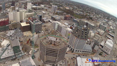
A snapshot from GPS Boomerang's SmartBird flight over the Christchurch red zone on 23 December 2012, looking over the Arts Centre with Christ's College to the right.

Re:Start mall decorated with flowers, and street lights with red and black banners. In the background is a Wilson's carpark where a building use to be.

The damaged tower of Christ Church Cathedral. The photograph was taken from a walkway that was opened up to allow the public to see inside the Red Zone.

Photograph captioned by BeckerFraserPhotos, "Oxford Terrace pump house".

Photograph captioned by BeckerFraserPhotos, "Oran and Waitaki Streets, Bexley".

A snapshot from GPS Boomerang's SmartBird flight over the Christchurch red zone on 5 June 2012, looking over Bedford Row with Latimer Square in the distance to the left.
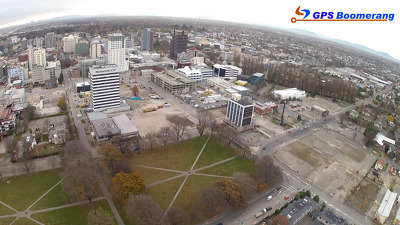
A snapshot from GPS Boomerang's SmartBird flight over the Christchurch red zone on 5 June 2012, looking over Latimer Square with the CTV Building site visible on the right.
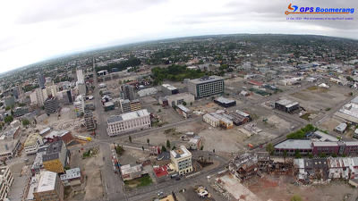
A snapshot from GPS Boomerang's SmartBird flight over the Christchurch red zone on 5 June 2012, looking over High Street with the front of Alice in Videoland visible.

A snapshot from GPS Boomerang's SmartBird flight over the Christchurch red zone on 23 December 2012, looking over Latimer Square with the CTV Building site visible on the right.

A snapshot from GPS Boomerang's SmartBird flight over the Christchurch red zone on 23 December 2012, looking over Madras Street with the High Street shops in the bottom left.
A snapshot from GPS Boomerang's SmartBird flight over the Christchurch red zone on 23 December 2012, looking over High Street with the front of Alice in Videoland visible.

Looking into the Red Zone from the viewing windows at the east end of Re:Start mall. The Wespac and Crossing building can be seen in the background.

Portaloos on the Pine Mound, part of Festival of Flowers. Each portaloo was decorated with various floral features. This one has been decorated in Canterbury colours, red and black.
A snapshot from GPS Boomerang's SmartBird flight over the Christchurch red zone on 5 June 2012, looking over Cathedral Square with the Cathedral and the Post Office visible.

Photograph captioned by BeckerFraserPhotos, "Bexley Road and Waitaki Street".
A snapshot from GPS Boomerang's SmartBird flight over the Christchurch red zone on 5 June 2012, looking over the Westpac Trust Building towards the Holiday Inn.

A snapshot from GPS Boomerang's SmartBird flight over the Christchurch red zone on 5 June 2012, looking over Cashel Street where the Re:Start container mall now sits.